Maps of Early Colonial America

Portolan atlas of 9 charts and a world map. Manuscript, pen-and-ink and watercolor, on vellum, by Battista Agnese ca. 1544. Dedicated to Hieronymus Ruffault, Abbot of St. Vaast. Each double-page illumination (col. diagrs., col. maps) 21 x 29 cm. Compass rose on inside back cover. "Maps 1, 2, and 10 show America. No. 1 shows the Gulf of California which Ulloa discovered in 1539. On the same map Yucatan is shown as an island, and the east and west coasts of North and South America are only partially shown. On no. 2, the east coasts of North and South America are shown in their entirety and the west coasts only partially. Clumps of trees in green and gold are shown on no. 1, near the Noluccas, and on no. 2, in the Brazilian region of South America. The oval world map (no. 10) shows Magellan's route around the world and a route from Spain to Peru. The 12 wind cherubs on this map are named." -- Ristow and Skelton, Nautical charts on vellum in the Library of Congress, 1977. DIGITAL ID: g3200m gct00001 URL: http://hdl.loc.gov/loc.gmd/g3200m.gct00001 SOURCE: Library of Congress Geography and Map Division Washington, D.C.
1544 Agnese vbg - bg
1544 Agnese


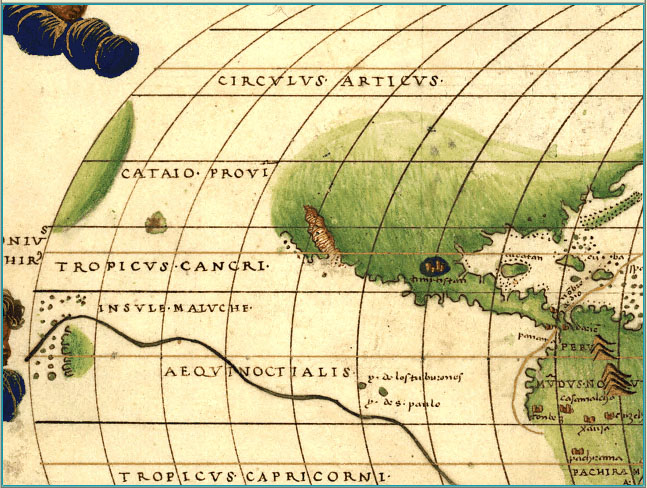
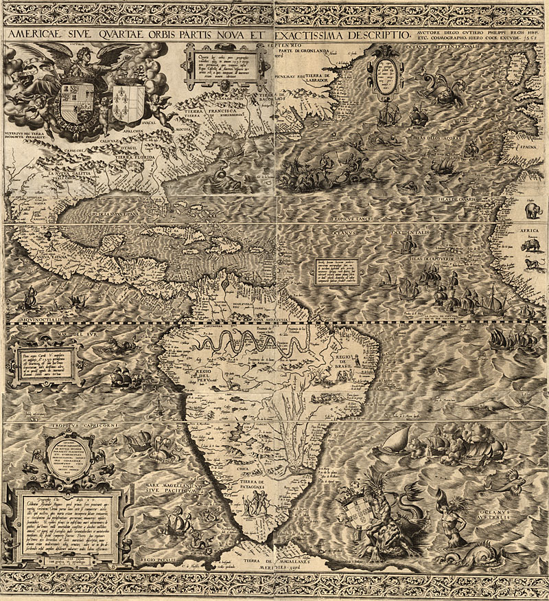
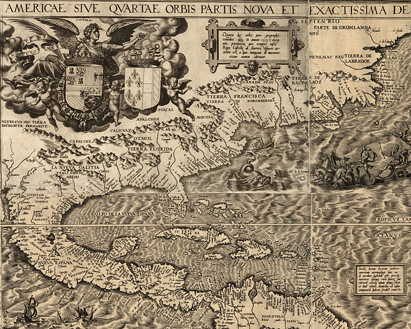
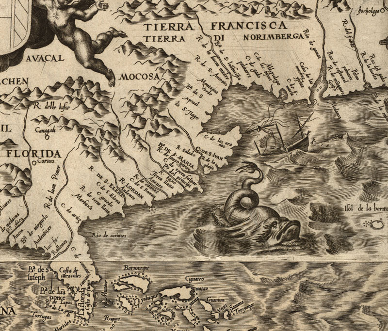
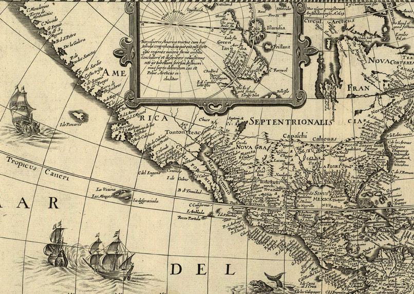
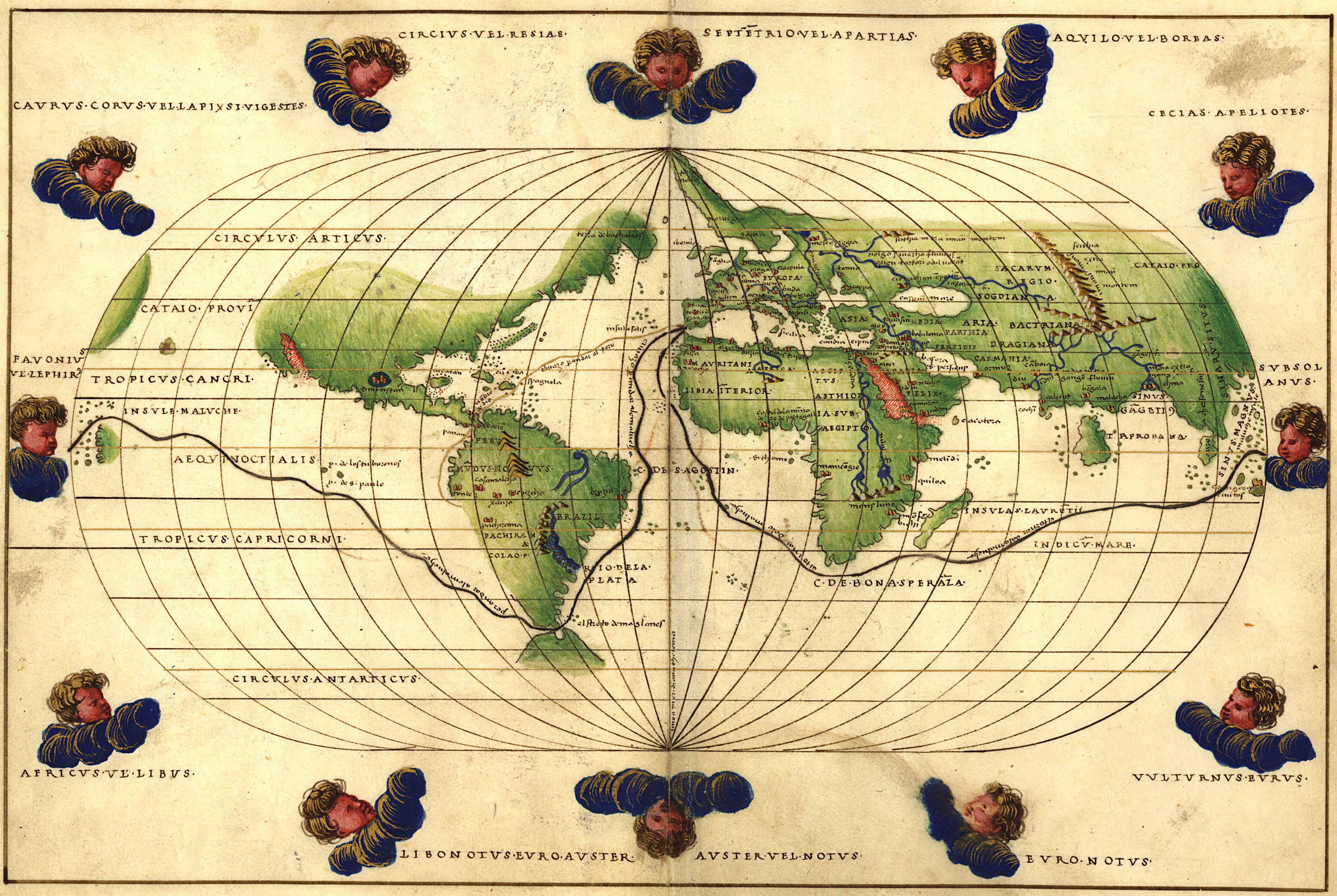
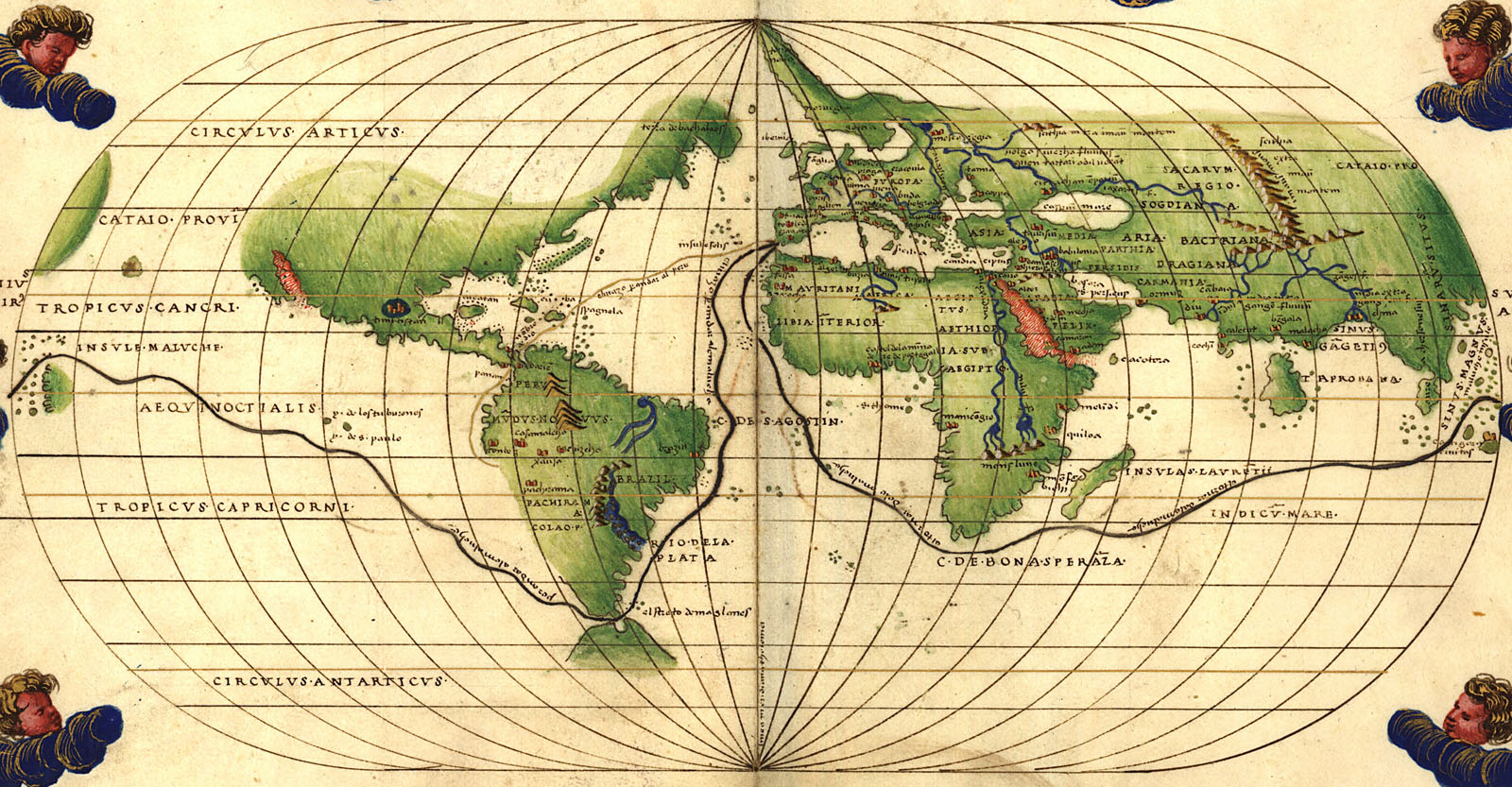
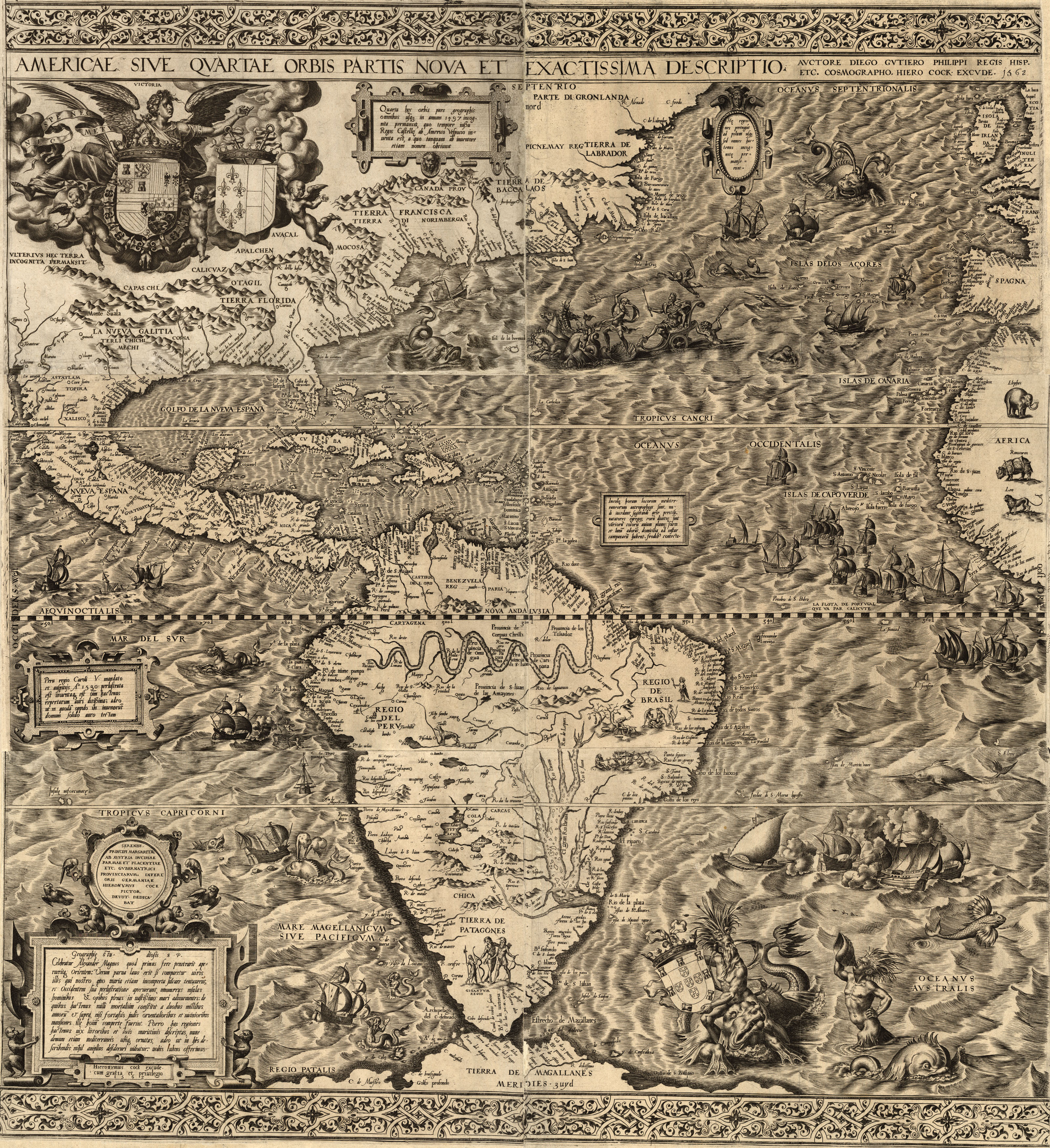
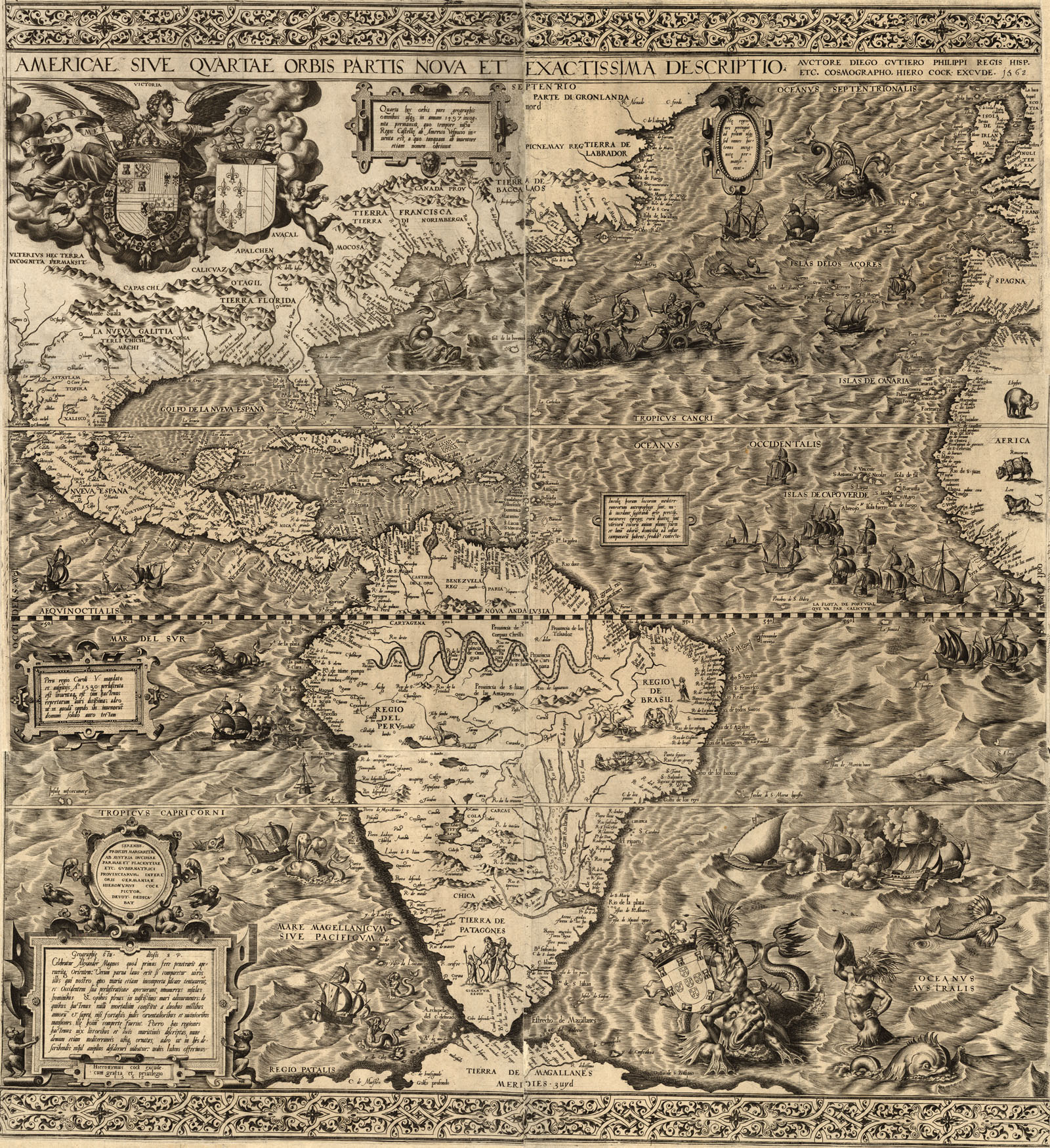
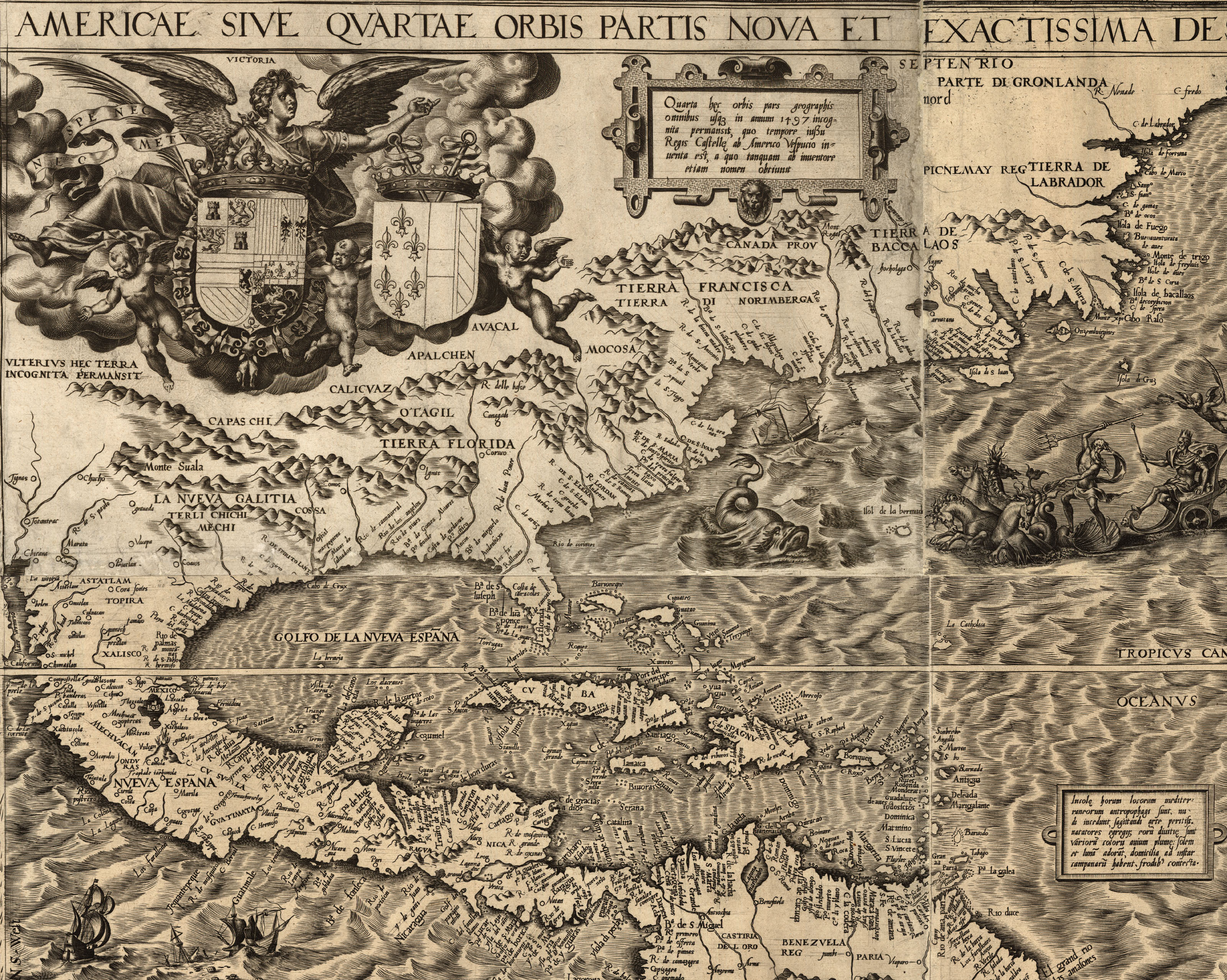
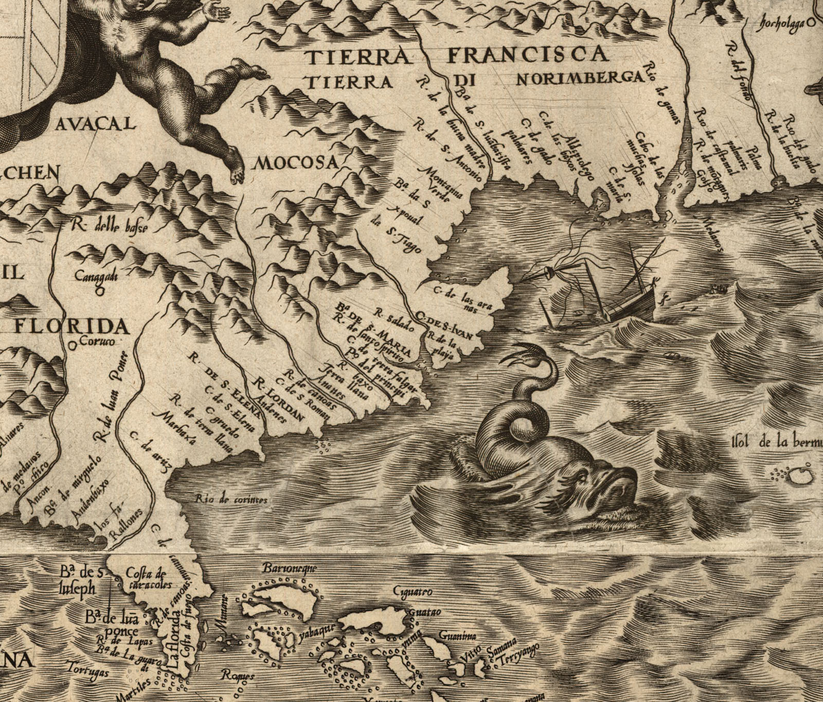
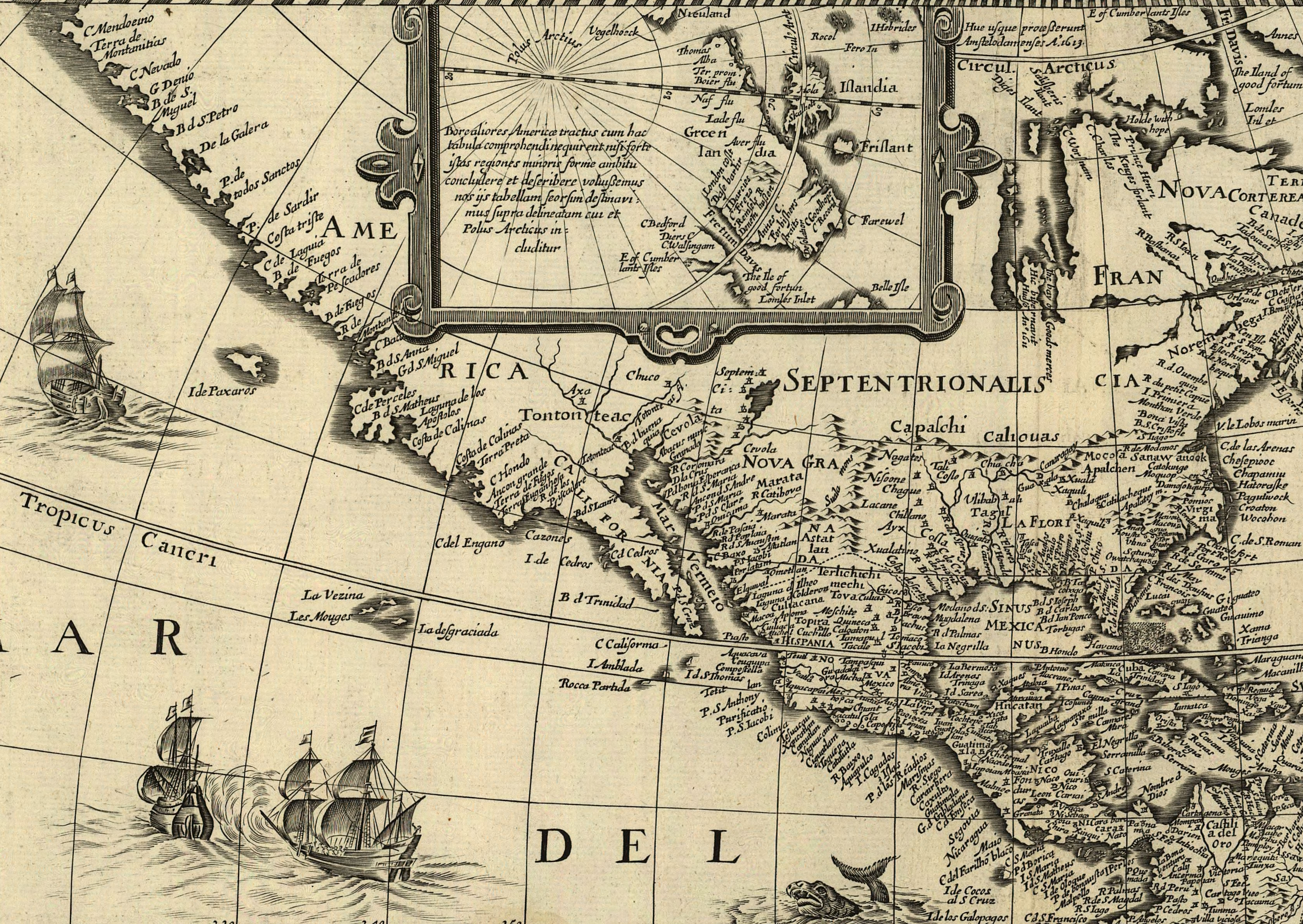
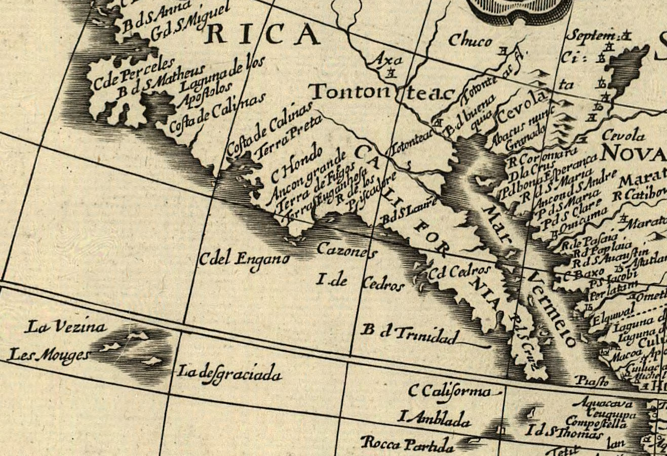
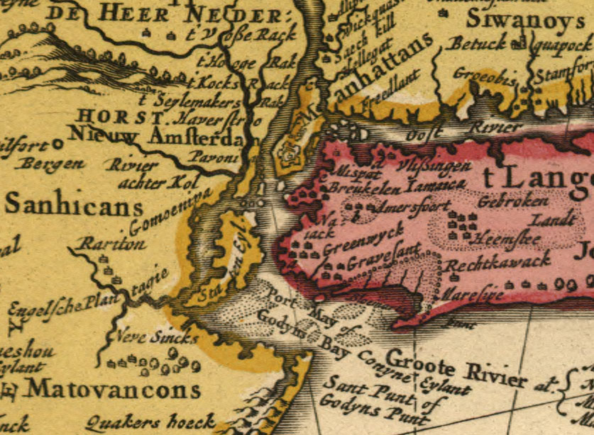
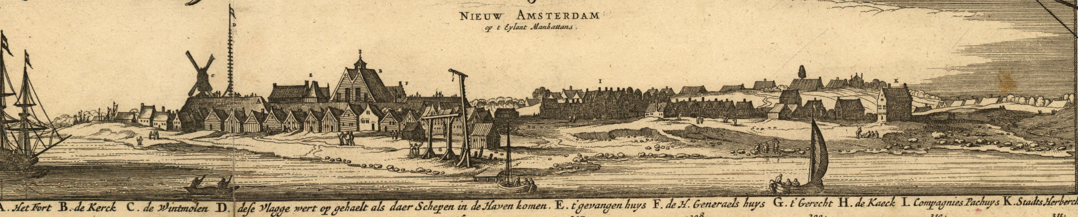
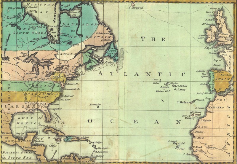
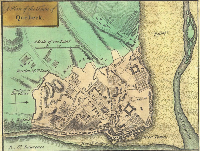
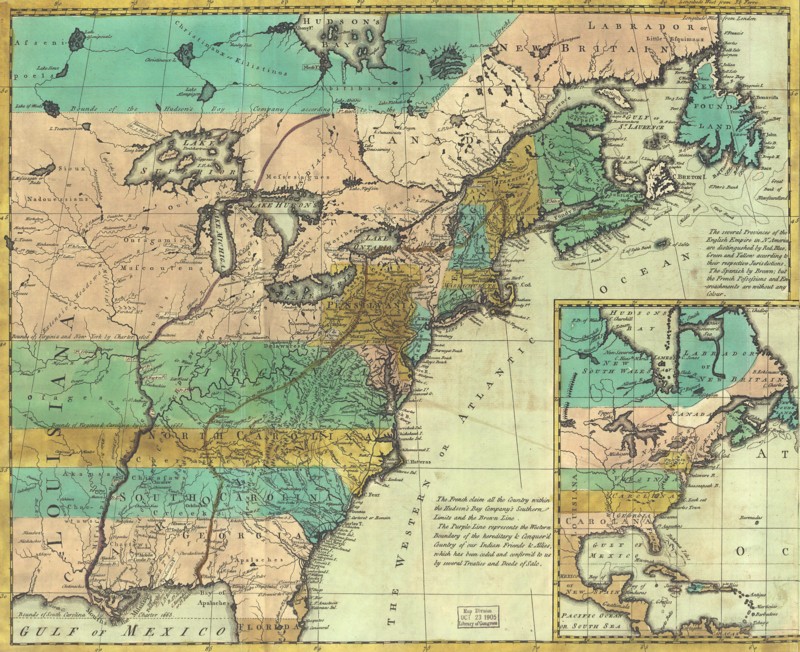
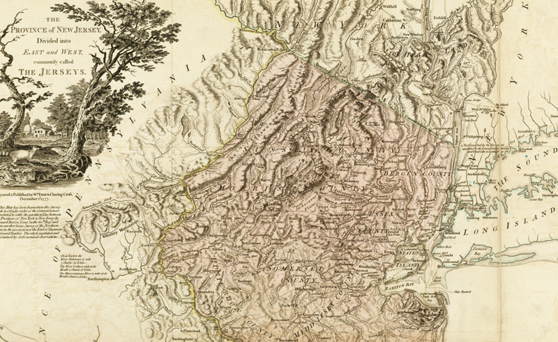
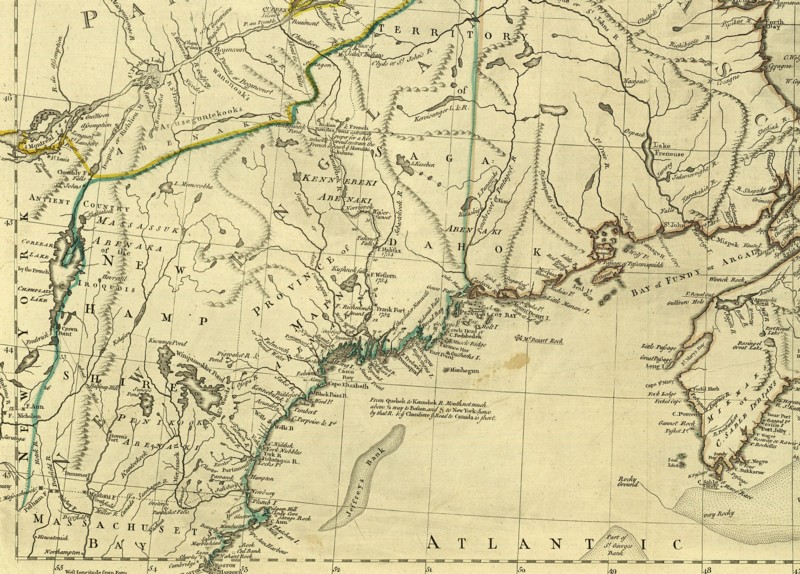
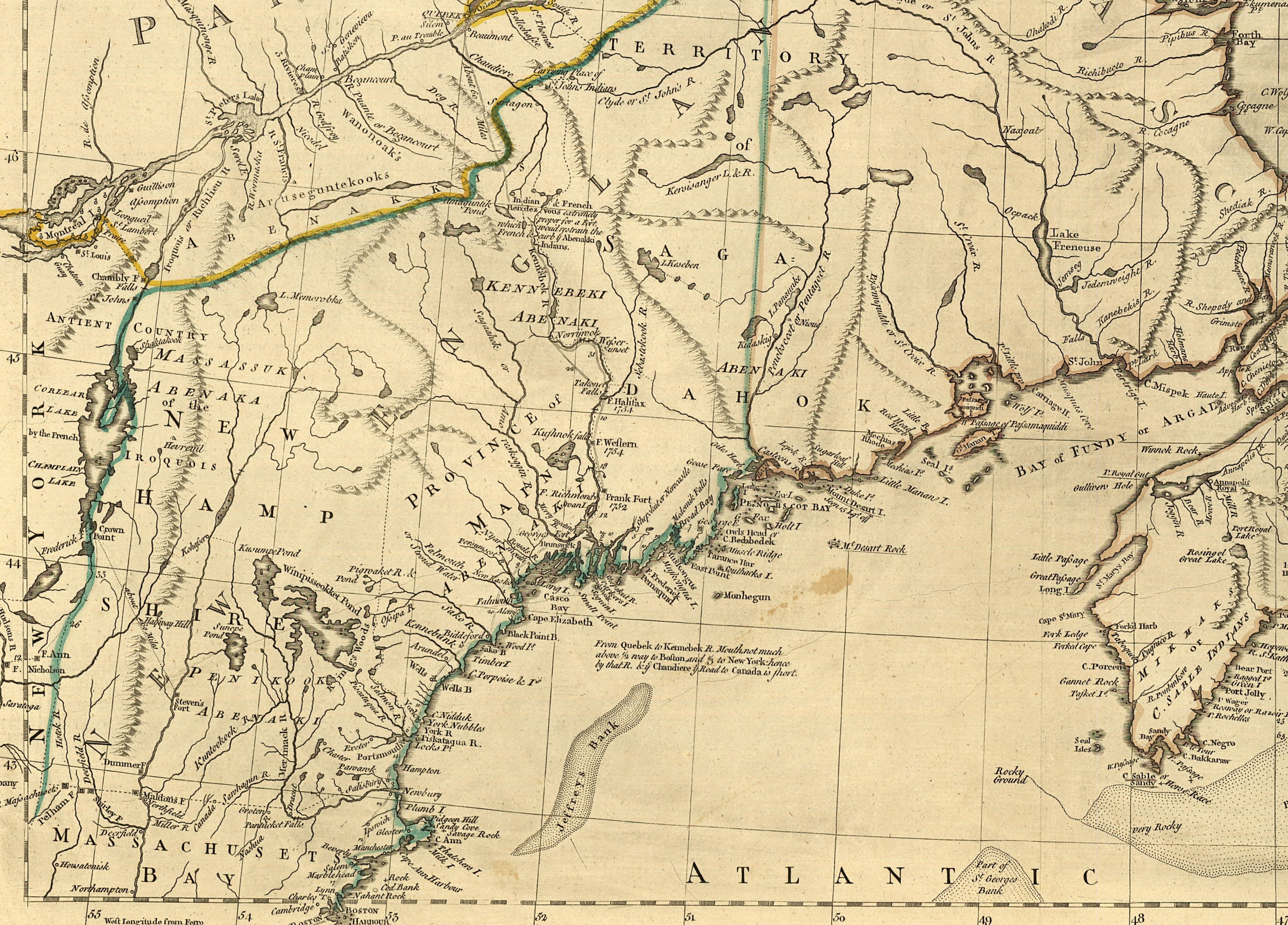
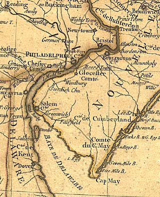
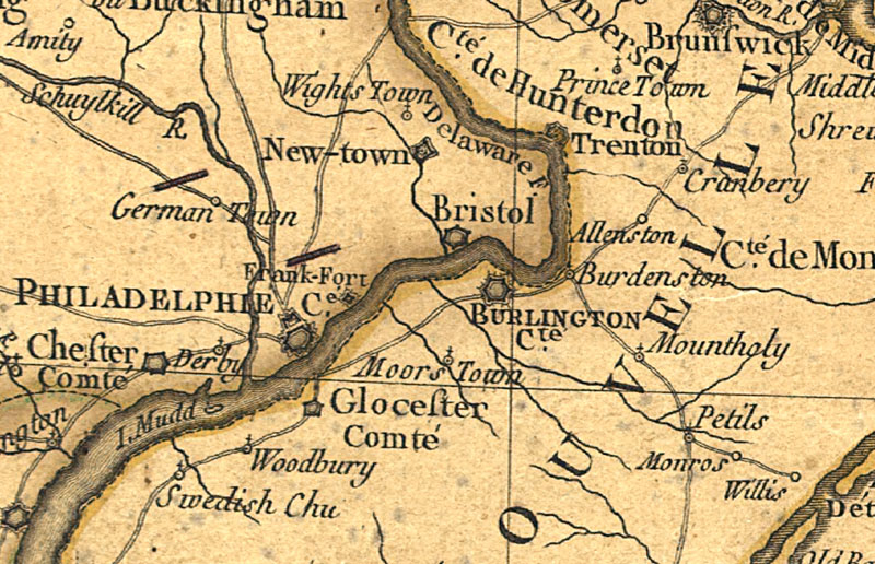
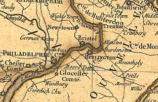
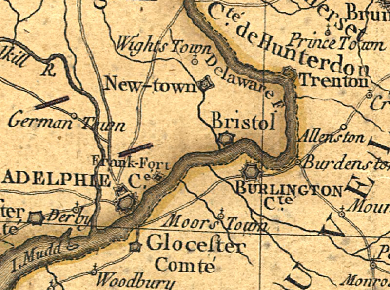
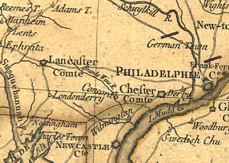
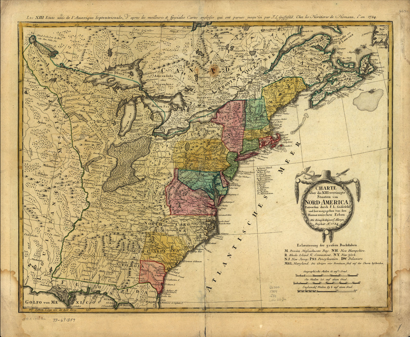
North and South America with the adjacent seas by Diego Gutiérrez 1562. Originally printed in 6 sections on sheet 93 x 86 cm. Featured in LC Map Collection Discovery and Exploration: "In 1562 Diego Gutierrez, a Spanish cartographer from the respected Casa de la Contratación , and Hieronymus Cock, a noted engraver from Antwerp, collaborated in the preparation of a spectacular and ornate map of what was then referred to as the fourth part of the world, America. It was the largest engraved map of America to that time. Substantial mystery surrounds this map more than four hundred years after its creation. Confusion over its authorship, the location of its printing, and the reasons even for its preparation remains. The fact that only two known copies of this printed map are extant, one located in the Library of Congress (Washington, D.C.) and the other preserved in the British Library (London) no doubt contributes to our lack of knowledge about this valuable and authoritative depiction of Spanish dominion in its new world, America. It contains a unique title identifying America as the fourth part of the world. The map provides a richly illustrated view of an America filled with images and names that had been popularized in Europe following Columbus's 1492 voyage of discovery. Images of parrots, monkeys, mermaids, fearsome sea creatures, cannibals, Patagonian giants, and an erupting volcano in central Mexico complement the numerous settlements, rivers, mountains, and capes named. It contains one of the earliest references to California, for on it " C. California" is located on the southern tip of Baja California. The map correctly recognizes the presence of the Amazon River system, other rivers of South America, Lake Titicaca, the location of Potos? and Mexico City, Florida and the greater southeastern part of the United States, and myriad coastal features of South, Central, North, and Caribbean America. It was to be the largest printed Spanish map of America to appear before the late eighteenth century. The April 3, 1559 Treaty of Cateau Cambr?sis between Spain and France is a key event in the map's preparation. That treaty and another signed on April 2, 1559 between France and England are known collectively as the Peace of Cateau Cambresis. Those treaties contained the most comprehensive agreements drawn up before the Peace of Westphalia in the seventeenth century, thus effectively establishing legal and political status quo for Western Europe for ninety years. Concluded with the treaty was a French-Spanish agreement, namely the marriage of Elizabeth of Valois, daughter of Henry II, King of France, to Philip II in the summer of 1559. The marriage alliance between the two kingdoms is possibly an explanation for the very close positioning of the coats of arms of Spain and France on the Gutierrez map. An apparent oral agreement between French and Spanish negotiators at Cateau Cambresis concluded that the geographical parameters of the treaty were not to extend to non-European areas, for example, in America, where the French claimed the right to trade, which Spain denied. 1562 map of America was not intended to be a scientifically or navigationally exacting document, although it was of large scale and remained the largest map of America for a century. It was, rather, a ceremonial map, a diplomatic map, as identified by the coats of arms proclaiming possession. Through the map, Spain proclaimed to the nations of Western Europe its American territory, clearly outlining its sphere of control, not by degrees, but with the appearance of a very broad line for the Tropic of Cancer clearly drawn on the map. The Gutierrez map of America has rarely gained the recognition and the study that it deserves. Perhaps its uniqueness, with only two known copies extant, has contributed to its relative obscurity in cartographic literature."
DIGITAL ID: g3290 ct000342
URL: http://hdl.loc.gov/loc.gmd/ g3290 .ct000342
SOURCE: Library of Congress Geography and Map Division Washington, D.C
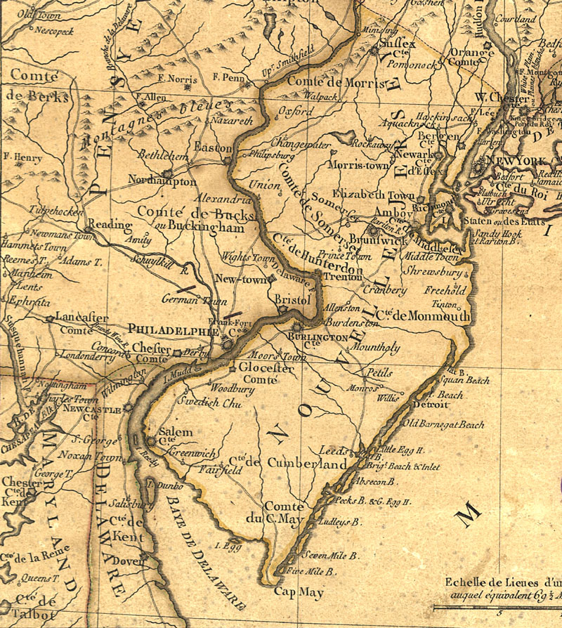
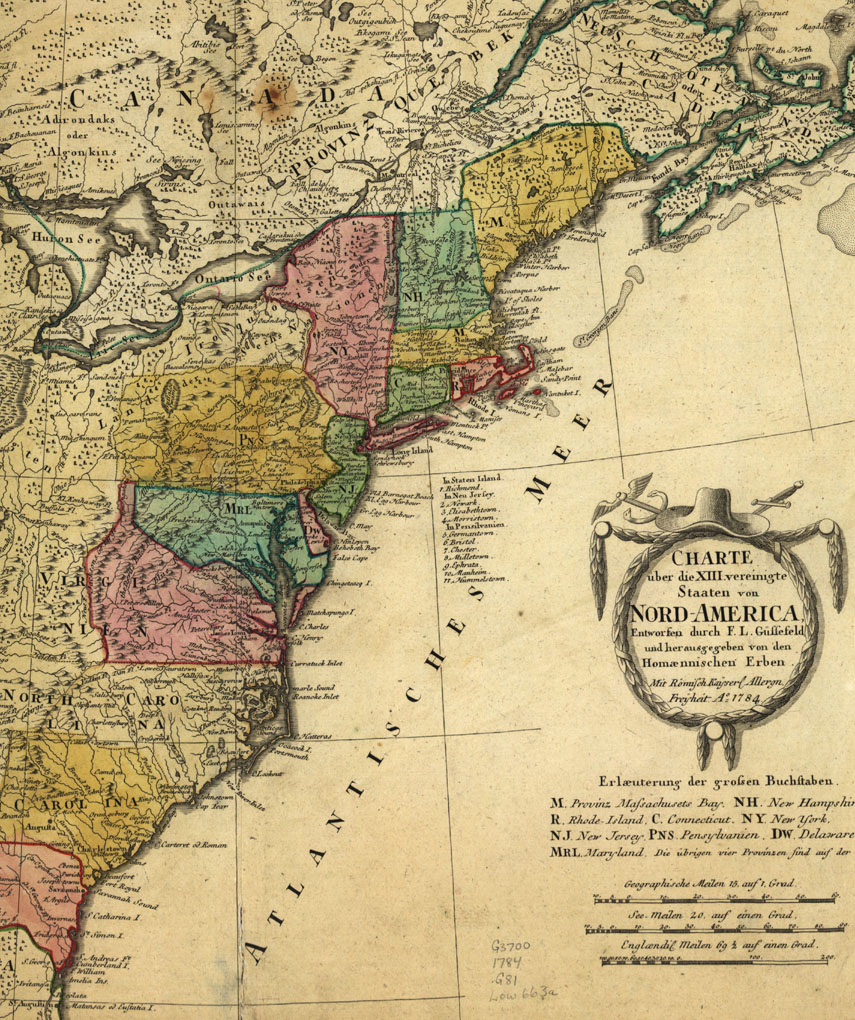
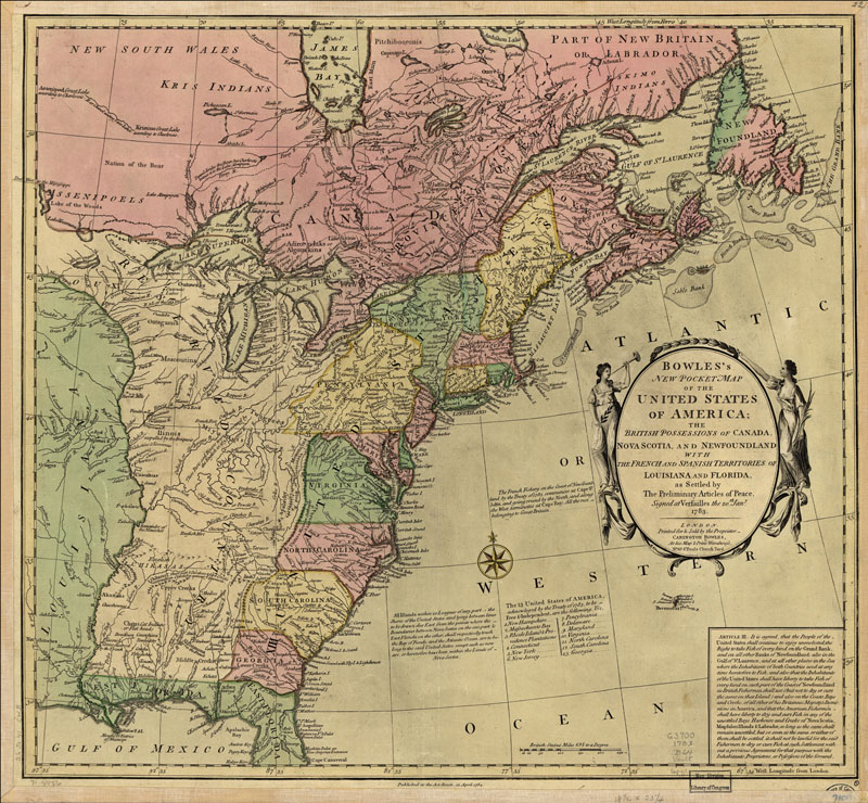
1562 Gutierrez - vbg - bg
1562 Gutierrez cu1 - 2bg and vbg
1562 Gutierrez cu1 - bg


Circumnavigation of The Globe by Jodocus Hondius (1563-1611) Vera Totius Expeditionis Nauticae . . . . Possibly Amsterdam, ca. 1595 Hand-colored engraving. Published by noted Dutch cartographer Jodocus Hondius, this elaborate double-hemisphere world map records the first English circumnavigation of the globe by Sir Francis Drake (1577-1580), as well as that of his countryman Thomas Cavendish a few years later (1586-1588). The map portrays the outlines of continents leaving the interiors blank, suggesting that the land areas were left unexplored. The marginalia includes the Elizabethan coat-of-arms, a vignette of Drake's ship the Golden Hind, and four corner illustrations. The drawing in the upper-left corner shows Drake's landing at Nova Albion in present-day California. URL: http://www.loc.gov/exhibits/treasures/trr059.html SOURCE: Library of Congress Geography and Map Division Washington, D.C.
1595 Hondius - 2


New England 1624 by Joannes de Laet (1593-1649). DIGITAL ID: g3300 np000003 URL: http://hdl.loc.gov/loc.gmd/g3300.np000003 SOURCE: Library of Congress Geography and Map Division Washington, D.C.
1624 New England - bg


New York and Manhattan region "Manatvs gelegen op de Noot [sic] Riuier" by Joan Vinckeboons, 1639. Pen-and-ink and watercolor. Pictorial map showing buildings and points of interest. Depths shown by soundings. Includes index of buildings with householders' names. DIGITAL ID: g3804n ct000050 URL: http://hdl.loc.gov/loc.gmd/g3804n.ct000050 SOURCE: Library of Congress Geography and Map Division Washington, D.C.
1639 New York and bg - a - b


America noviter delineata by Jodocus Hondius, Paris, 1640. Relief shown pictorially. Includes insets of north and south polar regions. DIGITAL ID: g3290 np000144 URL: http://hdl.loc.gov/loc.gmd/g3290.np000144 SOURCE: Library of Congress Geography and Map Division Washington, D.C.
1640 Hondius and bg - b and bg


"Novi Belgii Novæque Angliæ : nec non partis Virginiæ tabula multis in locis emendata, Nieuw Amsterdam op t eylant Manhattans" by Nicolaum Visscher, Amsterdam, 1685. DIGITAL ID: g3715 ct000001 URL: http://hdl.loc.gov/loc.gmd/g3715.ct000001 SOURCE: Library of Congress Geography and Map Division Washington, D.C.


A new and accurate map of the English empire in North America; Representing their rightful claim as confirmed by charters and the formal surrender of their Indian friends; likewise the encroachments of the French, with the several forts they have unjustly erected therein. Society of Anti-Gallicans. Sold by Wm. Herbert & Robt. Sayer, London, 1755. Hand colored. Relief shown pictorially. Maps in margin: A plan of the harbor and town of Louisbourg on the isle of Cape Briton.--A plan of Chebucto Harbor.--The Atlantic Ocean.--Fort Frederick built by the French at Crown or Scalp Point in the year 1731.--A plan of Port Dauphin on the isle of Cape Briton.--A plan of the harbour of Annopolis Royal.--A plan of the town of Quebeck. DIGITAL ID: g3300 ar006200 URL: http://hdl.loc.gov/loc.gmd/g3300.ar006200 SOURCE: Library of Congress Geography and Map Division Washington, D.C.
1755 Canada and b - c - d


Plan of Fort William Henry and camp at Lake George, 1755, drawn by William Eyre, engineer, and Joseph Heath, pen-and-ink and watercolor. DIGITAL ID: g3804l ar112100 URL: http://hdl.loc.gov/loc.gmd/g3804l.ar112100 SOURCE: Library of Congress Geography and Map Division Washington, D.C.
1755 Fort Wiliam Henry and bg - h


A Plan of Albany, as it was in the year 1758, pen-and-ink and watercolor. Oriented with north to the right. DIGITAL ID: g3804a ar112900 URL: http://hdl.loc.gov/loc.gmd/g3804a.ar112900 SOURCE: Library of Congress Geography and Map Division Washington, D.C.
1758 Albany and bg - mid - cu - h


Plan of a rout undertaken in winter, Jany. 26th, from Quebec, the capital of Canada, to the frontier settlements of the Township of Topsham near Brunswick Fort on the River Ammerascaegun in the Province of New Hampshire, Feby. 20th 1760. By John Montresor, sub. engr. & lieut. (1736-1799). Manuscript; pen-and-ink and watercolor. Oriented with north to the right. Relief shown pictorially. DIGITAL ID: g3734t ar080800 URL: http://hdl.loc.gov/loc.gmd/g3734t.ar080800 SOURCE: Library of Congress Geography and Map Division Washington, D.C
1760 Topsham and bg left - bg mid - bg right - b and bg - c and bg - d and bg


"The Province of New Jersey, divided into East and West, commonly called the Jerseys. Shows county boundaries and Division line run in 1743 between East New Jersey and West New Jersey. This map has been drawn from the survey made in 1769 by Bernard Ratzer and from another large survey of the northern parts by Gerard Banker. Includes table of "Astronomical observations." Engraved & published by Wm. Faden, London 1777. DIGITAL ID: g3810 ct000079 URL: http://hdl.loc.gov/loc.gmd/g3810.ct000079 SOURCE: Library of Congress Geography and Map Division Washington, D.C.
1769 New Jersey and bg - top and toph and top bg - bott and botth and bott bg - c and ch - h


Caribbean Area 1774. "To His Royal Highness. George Augustus Frederick. Prince of Wales &c. &c. &c. This chart of the West Indies, is humbly inscribed by His Royal Highness faithful & obedient servant Joseph Smith Speer. Thos. Bowen, sculpt." at Westminster, 1774. Hand colored. Relief shown pictorially. Depths shown by soundings. Shows southern United States, Mexico, Central America, West Indies, Bermudas, and northern South America. Includes acknowledgment dated Jan. 25, 1774 at Plantation Office, Whitehall by John Pownall, secry. DIGITAL ID: g4390 ar169900 URL: http://hdl.loc.gov/loc.gmd/g4390.ar169900 SOURCE: Library of Congress Geography and Map Division Washington, D.C
1774 Caribbean and bg


"A new map of Nova Scotia, and Cape Breton Island with the adjacent parts of New England and Canada, composed from a great number of actual surveys; and other materials regulated by many new astronomical observations of the longitude as well as latitude; by Thomas Jefferys, geographer to the King." Printed & sold by R. Sayer & J. Bennett, London, 1775. Hand colored. Relief shown pictorially. Shows Maritime Provinces, New England, and St. Lawrence Valley region to Montreal. From the author's The American atlas. 1775. DIGITAL ID: g3420 np000010 URL: http://hdl.loc.gov/loc.gmd/g3420.np000010 SOURCE: Library of Congress Geography and Map Division Washington, D.C
1775 Maine and bg - b and bg - c


New Jersey area 1777 SOURCE: Library of Congress Geography and Map Division Washington, D.C
1777 New Jersey area and ah - b and bh - c and ch - d and dh - e and eh


Charte über de XIII Vereinigte Staaten von Nord-America, entworfen durch F. L. Güssefeld und hrsg. von den Homænnischen Erben. Published 1784. Title in margin: Les XIII Etats Unis de l'Amerique septentrionale, d'apress les meilleures & speciales carte angloises qui ont parues jusqu'ci. Hand colored. Relief shown pictorially. From publisher's Atlas geographicvs. 1759 [i.e. 1784] v.3, no. 65. DIGITAL ID: g3700 ar075703 URL: http://hdl.loc.gov/loc.gmd/g3700.ar075703 SOURCE: Library of Congress Geography and Map Division Washington, D.C
1784 map by Gussefeld and bg - a and abg and ah and h


Bowles's new pocket map of the United States of America; the British possessions of Canada, Nova Scotia, and Newfoundland, with the French and Spanish territories of Louisiana and Florida, as settled by the preliminary articles of peace signed at Versailles the 20th. Jany. 1783. By Carington Bowles (1724-1793), published London, 1784. Hand colored. Relief shown pictorially. Includes historic notes, listing of "The 13 United States of America," and inset "Article III." DIGITAL ID: g3700 ar074500 URL: http://hdl.loc.gov/loc.gmd/g3700.ar074500 SOURCE: Library of Congress Geography and Map Division Washington, D.C
1784 Treaty and bg - b and bg


revised 9/20/02 by Schoenherr | Map list