|
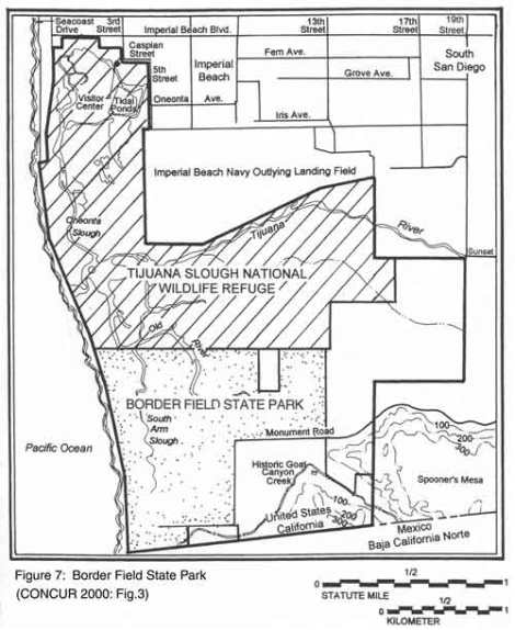
Border Field State Park
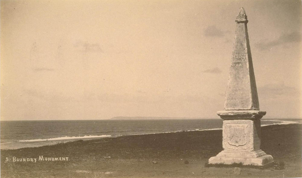
Boundary Marker Number 1 in 1889
1851 - In June 1849, a survey team of the International Boundary Commission led by Major William Emory fixed the "initial point" of the boundary between Mexico and the U.S. on the beach below the bluff that became known as Monument Mesa. This point was one marine league south of the lower tip of San Diego bay as shown by the 1782 map of Juan Pantoja attached to Article 5 of the 1848 Treaty of Guadalupe Hidalgo. Captain Edmund Hardcastle, of the U.S. Topographical Engineers, and Ricardo Ramírez, of the Mexican Boundary Commission, dedicated the first boundary monument on July 14, 1851. It was made of marble and weighed over 8 tons. It was known as Monument No. 1 until the Barlow-Blanco Commission renumbered the monuments in 1894 and it became Monument No. 258. This "Initial Point of Boundary" was placed on the National Register of Historic Places in 1974. 1862/08/17 - Jesus Maria Estudillo, age 18, on a visit to the Arguello Family at La Punta recorded a trip to the monument and the surrounding beaches and terrain that would later become Border Field State Park: "Sunday, August 17, 1862 At the house [La Punta] till eleven or twelve when Tula, Refugia, and Lola, with Jose Antonio and myself went to visit another monument at the point of boundary between the U.S. and Mexico. .. After visiting the sea shore and enjoyed a short time viewing the waves. I saw four antelope and deer, we came home soon after. It was very warm when we left the beach." ( Van Wormer, 2005, p. 7. ) 1916 - San Diego Border Camp was established by the Army in the vicinity of the present day Border Field State Park during the Mexican Revolutionary period 1916-1920. ( Hinds, 1986. ) 1925/06/03 - The legal contest over the ownership of Aztec City, so-called $5,000,000 amusement center site, has caused the Mexican government to dispatch Tijuana soldiers and police to Monument. They have orders to stay on the land until the controversy is placed in satisfactory shape. Pedro Badillo has been exercising the "possession Is nine-tenths" prerogative during recent months but he was ousted yesterday and his appeal to Mexico City received the cold shoulder, despite his claim to American citizenship. Proposed development of Aztec City into a resort, with a race track, gambling casinos and other features is mixed up in the contest for title. Jerome Bassity, several times claimant to concession rights at Tijuana, is a party. So is Badillo and so are four San Diego women. Mrs. Clara Sanchez and her three daughters. Mrs. H. Jauregui. Mrs. Maria S. Conotreras and Mrs. Douglas Anderson. ( San Diego Evening Tribune, June 3, 1925. )
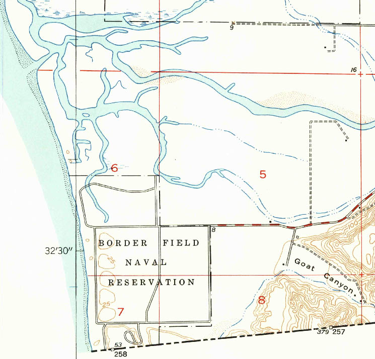
Border Field Naval Reservation 1953
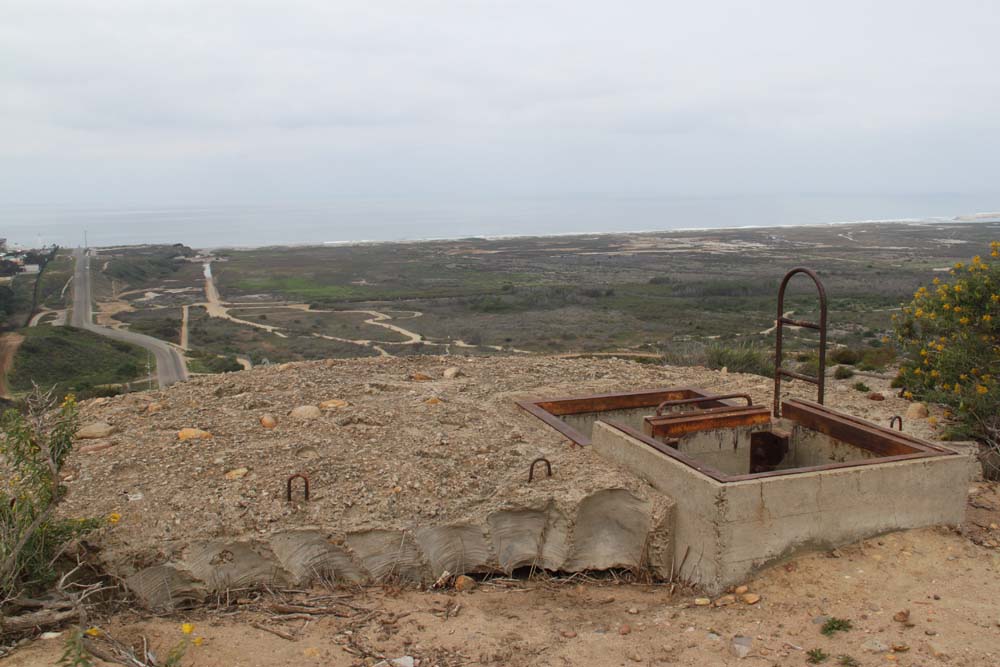
1929 - After 1920, the Army abandoned its Border Camp. In 1929 the Navy leased 58 acres at Border Field from the Century Corporation of San Diego California for use as "Additional Flying Field (Border Field)" In 1939 and 1940 tests were carried out at Border Field to determine the best point of aim for aircraft in the most efficient long range formation approach when firing a .30 caliber machine gun, in flight angles below the horizontal. Strips of target material were laid out at a dive bombing range at Border Field and four planes conducted firing runs at approximately 45 degree angles of dive from 500 to 700 yards. ( Van Wormer, 2005, p. 38) 1941 - The 1,500 plane program passed by Congress in 1941 recommended the expansion of Border Field for the use of dive bombing and gunnery training and practice landings during dry weather. Development plans called for a standard paved runway into the prevailing wind measuring 2,000 feet long by 300 feet wide. After further examination it was decided that the landing field would not be built at Border Field due to the excessive cost of drainage, since the field was a tidal marsh. The facility was developed as a practice gunnery range and designated Aircraft Gunnery Range Border Field. By June of 1942 the range had again been redesignated to Border Field Naval Operating Base. Five target ranges had been constructed in the sand dunes along the western edge of Border Field, just a few hundred yards from the shore line. An access road entered from an already existing county road along the north edge of the military property. A small cluster of buildings had been built near the southern edge of the tract at the base of the mesa where the initial monument had been erected in 1849. These included a range house, crew's quarters, gasoline storage, pump house, hose cart, motor generator house, latrine, water tank, civil guard house and shop. An observation building had been built on the northwest edge of the mesa where the Initial Border Monument stood. An access road led from the compound to the top of the mesa where the observation building was located. The target ranges consisted of five separate tracks where motorized tractors pulled moving targets. Each was laid out in an irregular oval shape. An additional target track that ran in a curving line northward form the buildings complex to the northern edge of the tract was designated a "mobile firing line." ( Van Wormer, 2005, p. 40) 1942 - During World War II three fire control stations, commonly known as "base end stations" for San Diego Harbor coastal defense gun batteries were constructed by the U.S. Army at Border Field on a bluff south of Goat Canyon and adjacent to the Mexican Border. ( Van Wormer, 2005, p. 41. )
1942 - Auxiliary Landing Field, Border Field was established on the site of the machine gun range. Border Field Measuring Station was located just north of the auxiliary landing field and operated by the Naval Electronics Laboratory. Observation Post 227 was located in the Border Field area. ( Hinds, 1986. ) 1942 - Victor Stewart, 94, and his family had been farming and ranching in the Tijuana River Valley since 1911. After the 1916 flood washed them out of their original house in the valley, the Stewarts moved into a new two-bedroom ranch house on 20 acres with a bunkhouse and outhouses. The Stewarts put up several soldiers in their bunkhouse during World War I and through the 1930s, until the barracks were built at Border Field Naval Air Station in 1942-43. After Pearl Harbor, the Navy built 35 structures by 1943 mostly temporary buildings including hutments, ordnance-storage facilities, shops and offices. The training programs in this makeshift installation included divebombing and free gunnery. Stewart said he wasn't scared in his border home after the war started, considering that there were sailors at Border Field, the Coast Guard in the ocean and the Army guarding the border -three men for every 100 yards. Stewart met Margaret "Peggy" Burns, 10 years his junior, at St. Rose Catholic Church. They were married in 1946, but while they were dating they often went to see movies at the theater at Border Field. Stewart and Peggy had two especially close friends, Merritt Wenzel and Harlan Case, both instructors at Border Field. Wenzel was known as the "Old Man" of the base because he was already in his 50s. Wenzel and Case were officers so they lived off-base with their families. The enlisted men lived in the barracks. Peggy would have one of the cooks trade cigarettes for steaks and take their favorite sailors on trips to the desert for a tour and cookout. Sailors from Border Field would work at Stewart's ranch for extra money from 1944-45. He would also get farmers' gas coupons, and he was nice enough to drive the enlisted around town. (By Anne Marie Tipton, San Diego Union-Tribune, May 31, 2008.) 1952 - Auxiliary Landing Field, Border Field was used by the Navy for touch and go landings and was still active into the 1960s. It was also used for drone training in 1953. ( Hinds, 1986. ) 1964 - California voters approved funds in 1964 to acquire Border Field as a state park. Meanwhile, real estate speculators who had bought up nearby farmland were pushing a different agenda and mounting an intense federal lobbying effort. The development scheme called for encapsulating the Tijuana River into a concrete flood control channel. Once the flood-prone river was constrained, an upmarket marina would be planned, along with commercial and housing development. Opponents of the concrete channel sought to preserve the ecologically important Tijuana River estuary and discourage development in this unique border and beach space. ( Carter, 2011. ) 1971 - President Richard Nixon announced that Border Field would be developed for recreational use as part of his "Legacy of Parks" program. 372 acres became part of Border Field State Park, preserving the southern flank of the estuary. Meanwhile, local biologists Joy Zedler and Paul Jorgensen, along with Dr. Mike McCoy, a wildlife veterinarian, began to organize local environmentalists and Imperial Beach residents to build government and public support for the estuary's preservation. ( Tijuana River National Estuarine Research Reserve http://trnerr.org/ )
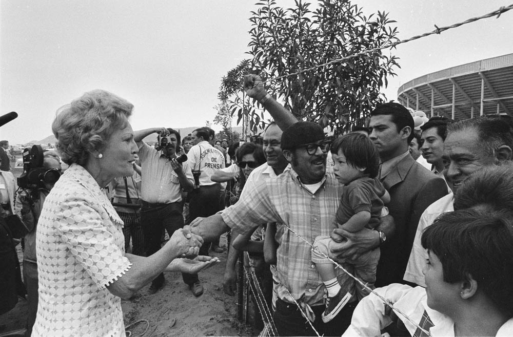
Pat Nixon greets Mexican citizens over the barbed wire fence at Border Field in 1971. (Nevins, 2008)
1971/08/18 - The establishment of an international recreational park at the border that would be both in Mexico and the United States had first been proposed in 1956. In June 1968 San Diego County park planners asked the State of California to spend a portion of park bond monies to acquire and land for the park. The following month the County Comprehensive Planning Organization urged action to acquire five million to acquire land for parks at Agua Hedionda Lagoon in Carlsbad and "International Park" at the border. In September 1970 the Navy formerly declared Border Field Auxiliary Landing Field surplus to its needs. On August 18, 1971, in a ceremony presided over by First Lady Mrs. Richard (Pat) Nixon, the Navy turned ownership of 372 acres at Border Field over to the State of California and the area became Border Field State Park. As part of the ceremony, Mrs. Nixon planted a tree that would be part of a future circle of trees that were intended to surround the border monument in both the United States and Mexico. Commenting that the barbed fence added an incongruous note to the scene she stated that she hoped it would not be there for too long. Mrs. Nixon then "took an unscheduled plunge into a reaching, waving, throng of Mexicans who lined the Tijuana side of the border to witness the ceremonies." In 1972 Governor Ronald Reagan allocated $104,638 to develop the new park. In 1974 the governor appropriated another $3 million dollars to acquire 300 additional acres for Border Field, which would add around 6,000 feet of beach front to the already existing mile of beach within the park. The original idea behind the creation an "international park" at Border Field had been to establish a place "to bring together people and events from both the United States and Mexico." A pedestrian crossing gate was established at the border monument and many visitors walked into Mexico to shop and eat at restaurants. The beach was quite beautiful and a main attraction. It was common for visitors to rent horses at one of the many equestrian ranches in the valley and ride to the beach at Border Field. The park was also a popular destination for young people on bicycles. The dream of an international park, however, was never fully realized. There was little development on the Mexican side of the monument. Since the 1980s environmental degradation, along with increased border security, has had a negative impact on Border Field. Silt, trash and polluted water are regularly washed into the area by the river and the drainage at Goat Canyon. Floods also closed access to the park for weeks at a time. As a result of increased border security brought about by the U.S. Government's Operation Gate Keeper in the 1990s, the pedestrian crossing at the monument has also been closed. ( Van Wormer, 2005. ) 1972/09/28 - Legislation was introduced in Congress this week by Sen. John V. Tunney (D-Calif.) to establish the Tia Juana Estuary as a national wildlife refuge. The bill, which would bring the estuary under the control of the Department of Interior's Bureau of Sport Fisheries and Wildlife, is designed to maintain the salt marsh which stretches between Imperial Beach and the U.S.-Mexican border as an undeveloped area. In his introductory remarks, Tunney called the slough one of the finest salt water marshes remaining along the California coastline. Tunney's action was an answer to the prayers of conservation groups which urged that the marsh remain undeveloped. Citizens Coordinate for Century has strongly opposed development in the area and especially fought construction of a flood control channel to the ocean, which they see as a harbinger to development. A Tunney spokesman said the legislation would not prevent construction of a flood channel, but development would be nixed. A large variety of birds, ttsn invertebrates and other wildlife make their home in the marsh which opens naturally on the Pacific Ocean. The estuary is home seasonally or on a year-round basis to at least 173 species of water fowl and other birds, 26 species of fish, 42 species of large invertebrates, such as clams, snails, crabs and shrimp. Thirty-one species of marsh plants provide either food or shelter for much of the marsh life. The coastal wetlands and estuarine acreage in Southern California is only 31,700 acres, less than 25 percent of the acreage which existed in 1900. Great portions of the state's estuaries have been bulkheaded or filled for industrial and commercial purposes, resulting in greatly decreased numbers of fish and wildlife, according to Tunney. In San Diego Bay 80 to 85 percent of the tidelands have been filled. Sanford Wilbur, a wildlife biologist at the Bureau of Sport Fisheries and Wildlife, stated in a bureau memorandum: "I doubt there is a better place on the West Coast to use Land and Water Conservation Fund monies for habitat really essential to wildlife." ( Imperial Beach Star-News, Sept. 28, 1972 ) 1980/12/28 - Imperial Beach's hopes for a marina in the Tia Juana Estuary were shattered this week when it learned that the U.S. Fish and Wildlife Service has purchased 500 acres of the estuary for a wildlife preserve. ( Imperial Beach Star-News, Dec. 28, 1980 )
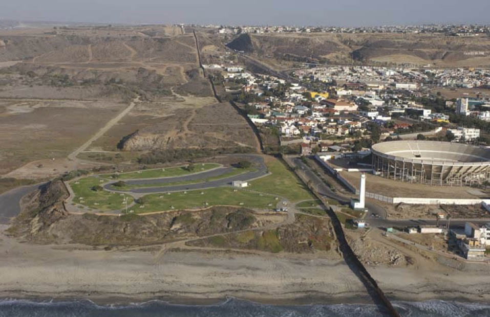
Border State Park and Tijuana National Wildlife Refuge in 2000.
1982 - In spite of heated opposition from developers, the the 2,800 acre Tijuana River National Estuary, both State Park and National Wildlife Refuge land, became part of the U.S. Department of Commerce's National Estuarine Sanctuary Program, and designated a National Estuarine Research Reserve. ( Tijuana River National Estuarine Research Reserve History ) 1994 - Political pressure on the federal government for stricter border control led to Operation Gatekeeper in 1994, a policy aimed at halting illegal entry into the United States. This controversial strategy targeted the San Diego portion of the border and exerted intense pressures on Border Field State Park. Among other changes, Monument No. 1 was flanked by a tall and inhospitable metal fence. ( Carter, 2011. ) 1996/06/25 - Using a grader, a loader, a dump truck and a lot of determination, cleanup crews removed silt and trash from the entrance of Border Field State Park last week. Over the years, heavy winter storms and raw sewage flowing in from Mexico had deposited so much sediment on the entrance road into the park, on the coast at the border, that it piled up at least 2 feet. "The hitching posts were buried to the point they looked like they were designed for miniature horses," said Imperial Beach resident Carolyn Powers, who has been complaining for a year and a half about the park's lengthy closures and the inhospitable entrance. "It looked closed, even if it was open," said Powers, chairwoman of Citizens Against Recreational Eviction, an organization aimed at educating the public and policy makers about South Bay recreation and environmental issues. Even when the park was open, she complained, the entrance gate was shut, public restrooms were chained, the entry kiosk was boarded up, and there wasn't anyone there to collect the $4 parking fee. New signs stating the park's hours went up a month ago. And a portable toilet was set up near the equestrian area. Powers spearheaded an effort to deal with what she saw as the biggest deterrent to the public: the dirt pile at the park's entrance. Ed Navarro, San Diego coast district superintendent of the state Parks and Recreation Department, said his department had planned to eventually remove the silt, but the equipment operator has been out sick, so the silt removal project would have to wait. Instead, Powers enlisted a crew of workers from the public and private sectors to clean up the park's entry this week and last. Among the workers this week were employees of the state Parks and Recreation Department, the U.S. Border Patrol, the National Guard, the city of San Diego, Traylor Bros. Corp. and Laidlaw Waste Systems. To wrap up the effort, the city of Imperial Beach plans to send a street sweeper to clean Monument Road. Prisoners from Donovan state prison will clean up around picnic tables and barbecues this week, Powers said. Navarro said two feet of silt was scraped from about a quarter mile of roadway leading up to the park's entrance. "I'm not sure we've solved all of our problems, at this point," Navarro said. "We've got the road open and the road cleaned off. But should we get an unexpected rain, we could have a real problem." The park, in the Tijuana River Valley at the Mexican border, includes barbecues, picnic tables, equestrian trails and an ocean view. It is open 10 a.m to sunset Thursdays through Sundays, Navarro said. With the silt-removal project almost completed, Powers is now aiming to get an employee stationed at the kiosk at the park's entry. Navarro said that may not happen anytime soon because the amount of visitation does not warrant it. ( San Diego Union-Tribune, June 25, 1996.
Monument Mesa in 2000 before the triple border fence was constructed. (CONCUR, 2000)
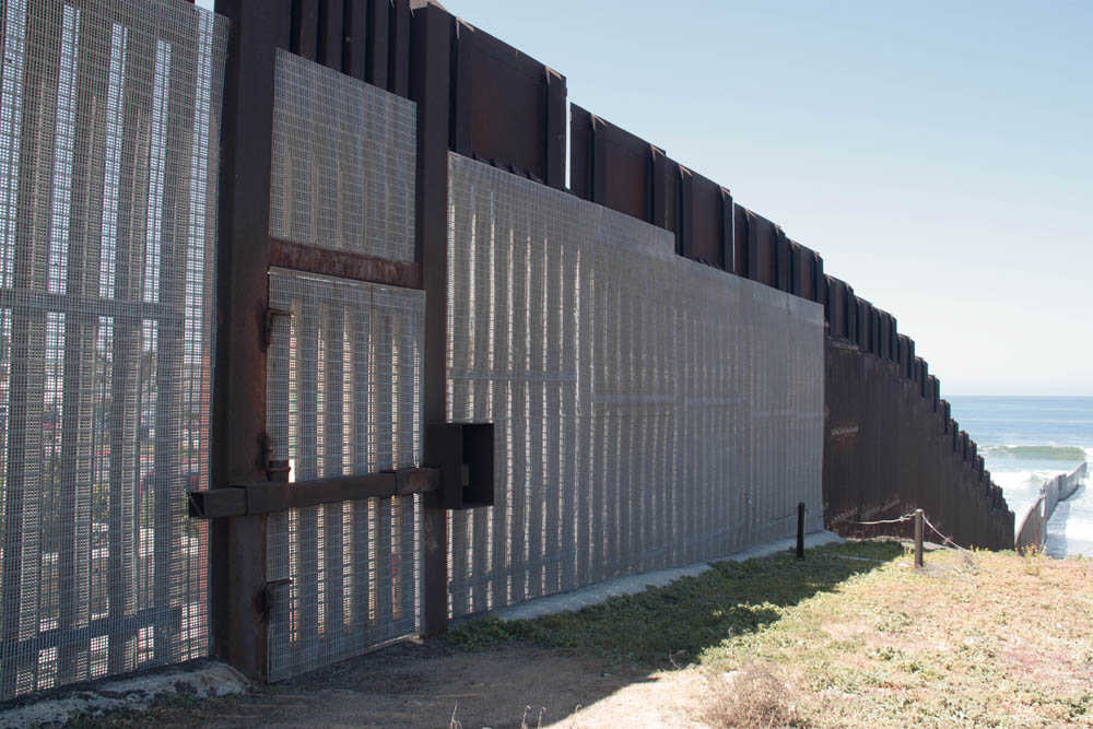
2008 - Homeland Security seized ownership of 150 feet of land running immediately along the boundary and began heavy construction of the "triple border fence" in 2008. To create the flat road and fence bed desired by border agents, 2.1 million cubic yards of dirt were needed to fill Smuggler's Gulch, a half-mile-long canyon. The landfill came from scraping the mesas of Border Field State Park. ( Carter, 2011. )
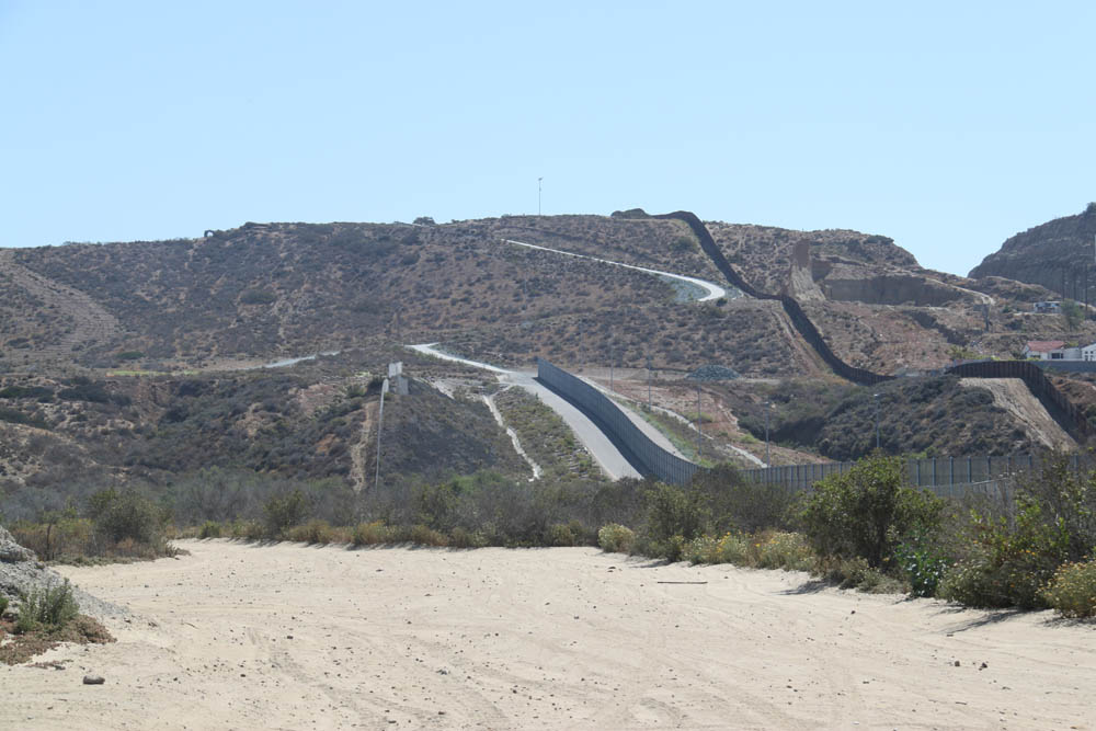
The triple border fence ends at the base of Bunker Hill, looking east from the base of Lichty Mesa in 2015.
2008/09/24 - As many Mexican-American families have done for years, they were there to spend the day with relatives unable to legally cross north to hug them and must be content to visit at the see-through fence. This binational social scene, as it exists now, is unique along the southern border of the United States. Soon, it will be a memory. The federal government's effort to slam the door on illegal immigration, drug smuggling and the threat of terrorism means a new secondary fence will be built in the park, creating a 90-foot-wide no-man's land of patrol roads and security lights that extends to the sea. Construction is to begin next month. The barrier will not be solid, but it will block most access to the primary fence, which is composed chiefly of loosely spaced metal pilings on the beach and mesh on the bluff above. Federal officials said a gate in the new fence will allow visitors to reach the 1851 border monument that marks the point where the United States and Mexico agreed on a common border after the Mexican-American War. The worn marble obelisk is accommodated by a cutout in the fence. Access details to a roughly 40-foot-wide space surrounding the monument are being worked out between federal and state officials. When the gate is closed, visitors will still be able to see into Mexico, but any socializing will be limited to waving from a distance. The construction, which involves installing a 15-foot-high picket-style fence that runs the length of the park, is part of a $60 million federal project that includes filling in Smuggler's Gulch, a deep canyon to the east. The idea to close gaps in a 14-mile section of secondary fence running inland from the ocean is part of a national security plan that has been in the works since the mid-1990s, said Angela de Rocha, a U.S. Customs and Border Protection spokeswoman. The project is not affected by a budget shortfall that could derail more recently authorized fencing along the southern border.Work in the park has begun. Visitors once could set up their chairs along the fence on the beach or on a dirt strip between the fence and the parking lot. Recently installed plastic mesh blocks access to all but the monument area and the lower section on the sand. The monument's history dates to shortly after the 1848 signing of the Treaty of Guadalupe Hidalgo in which Mexico ceded what is now the southwestern United States to its northern neighbor after the war. According to the Web site for Border Field State Park, delegations from both countries began surveying the boundary at this location in 1850, and the monument was erected shortly afterward. The marble spire became so popular that bits were chipped off as souvenirs; according to state parks officials, it had to be reshaped and re-installed in 1894. The area was dedicated as a state park in 1971, acquiring the nickname "Friendship Park" along the way. While a few informal meeting spots exist along the southern border, Border Field State Park is unique in that it is a refuge within an urban area where people can park their cars, pull a chair to the fence and spend the day with relatives and friends on the south side. ( San Diego Union-Tribune, Sept. 24, 2008. )
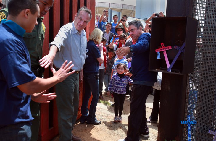
San Diego Mayor Bob Filner reaches for Luis Anguro, left, while Enrique Morones of the Border Angels holds back Anguro's daughter Ximena, 5,
on the Mexico side of the border. The Border Patrol permitted the opening of the heavy metal gate for two minutes on Sunday. (U-T San Diego, Apr. 28, 2013) ( 2013/04/28 - History was made at 12:13 p.m. Sunday afternoon at Border Field State Park as about 100 people on both sides of the international border looked on. It was then that a rusty steel door in the border fence between the United States and Mexico swung open, to a round of cheers and applause. It marked the first time since the construction of the fence in the mid-1990s that the door had opened. History lasted about two minutes. That was how long the gate stayed open, long enough for a father to step through and embrace his daughter on the other side, and for San Diego Mayor Bob Filner and his fiance Bronwyn Ingram to step though and say a few words. Then the gate swung close. The events were part of a unique celebration at Friendship Park, the small park right on the border that for years was the scene of weekend reunions between family members in the U.S. and Mexico. For years since the park opened in 1971 with a dedication by First Lady Pat Nixon, families met there and could hold hands and pass items through what was a simple chain link fence. The imposing steel fence was constructed in the 1990s and reinforced and rebuilt since then, said Enrique Morones, the founder and president of the group Border Angels, which organized Sunday's event. A second fence a few hundred feet north was built about a decade later. Access to the park was restricted and all but closed off in 2009 by the Department of Homeland Security as it constructed more fencing. It reopened last year on a limited basis, enough to allow families to visit with relatives in Mexico through the fence. However, thick steel mesh on the fence right on the border makes it difficult to see through and almost impossible to touch each other. Morones said the Border Patrol had agreed a couple of weeks ago to open the gate on Sunday briefly. It took some work with grease and blow torches to loosen the hinges and bolts, he said. "This is Friendship Park, the heart and soul of the immigration issue," he said. Border Angels were planning an event at the park for the commemoration of Children's Day, which falls on April 30 in Mexico, and is an annual holiday to celebrate children. The group planned to distribute toys to children on the Tijuana side to mark the day. What they had not planned on was Luis Angulo, who had come to the fence to see his five-year-old daughter Jimena on the Tijuana side. The two spoke through the fence when the park opened at 11 a.m. Then when the gate was opened, Angulo was allowed to step through and grab his daughter in an embrace. He said later it was the first time he had hugged her. The girl was born in Tijuana and he said he has not put the paperwork together to bring her over. "I think it's a miracle," he said afterward. Ingram was moved by the scene of father and daughter, brushing away tears at one point. Morones said she suggested that when the gate opened Angulo should be allowed to to pass through and embrace her. The original plan was to have a child from each side pass through and hug, but Morones said Ingram's idea was a more powerful one. He called the moment when father and daughter hugged "a moment I will never forget." Ingram said the gate opening was symbolic. "We're one area and it's great to celebrate that, and not think of the border as the end of the line or a cul-de-sac," she said. "We should be building bridges and opening gates instead of building these big walls that separate us." (By Greg Moran, U-T San Diego, Apr. 28, 2013.)
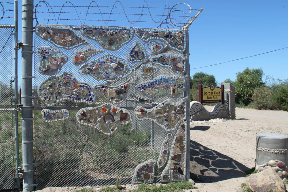
"The Border Field Gateway to Nature Communitree" in 2015
2014/10/16 The plaque on the fence at the gate to Border Field State Park describes the mosai artwork on the fence: "The Border Field Gateway to Nature Communitree.This project has been made possible though a collaboration between California State Parks, A Reason To Survive (ARTS) and The San Diego Foundation. Over 100 students, including many from local Southwest High School, artists and volunteers spent countless hours creating this spectacular artwork. The installation represents the Park's native Elderberry Tree and is made up of hundreds of hand made tiles that depict Plant and wildlife that are found here in the Tijuana River Estuary. Rocks, bones and other artifacts found here in the park are also included. The Tree will serve to engage and educate the community while it's branches stretch wide to welcome all visitors to enjoy the wonders of nature down by the border side. ARTS, The California State Parks and The San Diego Foundation truly believe in the power of the arts to bring community together, to raise consciousness, to inspire, to empower and to affect positive change in our world."
The locked door through the border fence west of the monument has been opened once a year sincec 2013, for Children's Day
Sources:
|
|||||||||||
|
Home •
About Us •
Next Meeting •
Latest News •
Resources •
Organizations •
Exhibits •
Bulletins
Contact
|
|||||||||||
|
This web page was created Apr. 18, 2015, by Steve Schoenherr for the South Bay Historical Society | Copyright © 2015
|