|
Coronado Cays and Silver Strand
by Steve Schoenherr
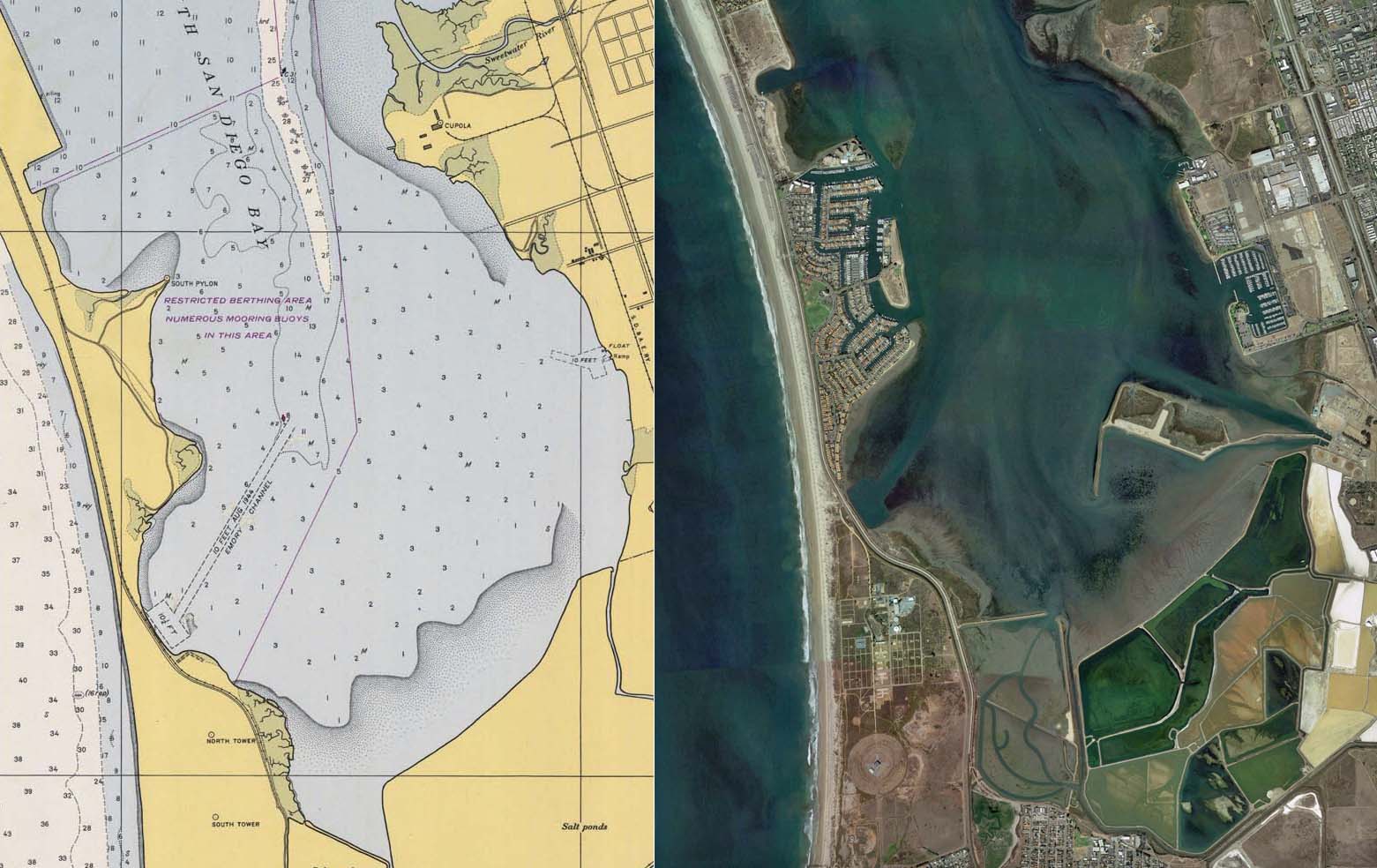
The Coronado Cays are shown from left to right, 1904 USGS map, 1948 USGS map, 2014 satellite view.
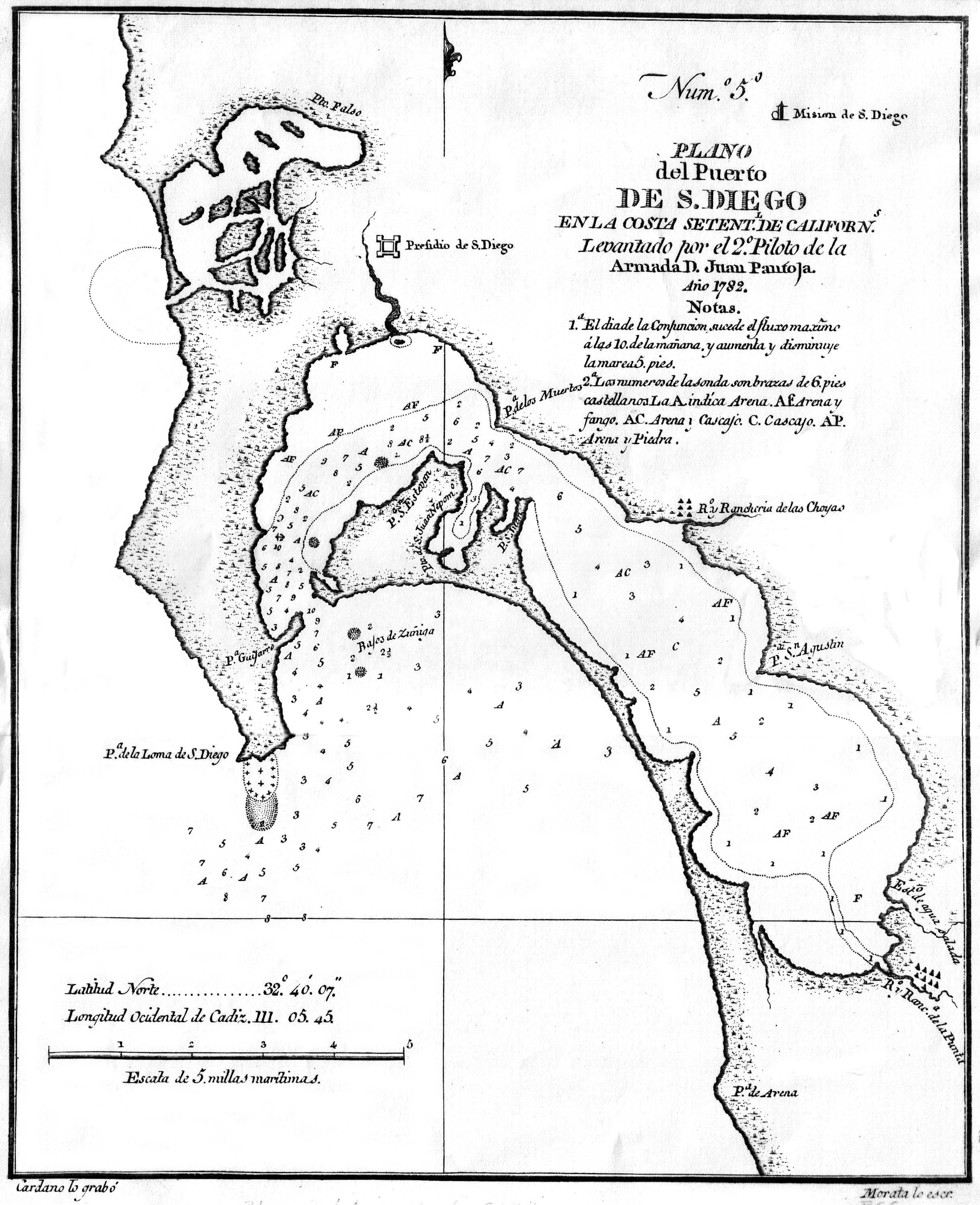
1782/09/12 - "It was on the voyage of the frigate Princesa to Southern California in 1782 that Juan Pantoja y Arriaga produced his best-known map, a detailed and reasonably accurate chart of San Diego harbor, surveyed during a seven-week layover. The ship dropped anchor at San Diego August 21. After completing preliminary work ("bearings and demarcations"), Pantoja outfitted the ship's launch with provisions and a crew "armed for war"(against possibly hostile Indians), and set out "to investigate all of this harbor with minute attention." First reconnoitering the coast to Todos Santos Bay (Ensenada), the party returned and devoted the afternoon of September 11 (Wednesday) to surveying the broad inlet ("Spanish Bight") that once separated Coronado and North Island. The surveyors spent Thursday (Sept. 12) along the 6-mile strand that encloses the bay on the west, landing twice, near present Coronado Cays marina to establish a baseline and make demarcations; and again to obtain the view from a bluff (now on the grounds of a U.S. Navy radio station). Rounding the head of the bay Friday morning, the party landed to fill water casks at the mouth of a river (Otay), then worked up the eastern shore, anchoring that night off the Choyas [Chollas] Indian rancheria (foot of 32nd Street.) Pantoja completed his swing around the bay Saturday, reboarding the Princesa at sunset. No trouble had been experienced with the natives, who came out repeatedly in reed canoes to look, to engage in trade, and to profess their Christianity." (The Voyage of the Frigate Princesa to Southern California in 1782, reviewed by Howard O. Welty, The Journal of San Diego History 30 (Winter 1984) ) - image of Pantoja map 1825 - The Russian fur trade ship Baikal visited San Diego 1825-26 hunting sea otters under an agreement of 1825 by the California Commissioner at Monterey to allow the Russian-American Fur Company to hunt sea otters in California. This Company had established Fort Ross near San Francisco in 1812. The Baikal may have used the fresh water spring on the Silver Strand as a base. The location of the spring was not only ideal for hunting sea otters off the Coronado Islands and Point Loma, but its location near the south end of San Diego bay where the Russians could easily collect salt in natural evaporation ponds. There are no historical records that show that the Russians harvested salt in San Diego bay, only at San Quentin bay in Baja. Salt was a very important commodity to the Russian-American Fur Company for tanning hides and they went to great difficulty and expense to obtain it. A pewter tablet with a Russian symbol was discovered on Coronado in 1968. There is no inscription on the tablet, only an early Russian insignia, an anchor and an ax. The fresh water spring was destroyed when the Coronado Cays were built. ("Russian Spring's Mystery," Chula Vista Historical Society Bulletin, Feb. and Mar. and Apr. 1983. ) - view article 1828 - According to Hubert Howe Bancroft, news came to San Diego from the north in 1828 that the smallpox was raging in the missions. James and Sylvester Pattie had arrived earlier that year but were believed to be Spanish spies and were thrown into prison where Sylvester died. James was released to act as an interpreter for the Mexican Governor Echeandia, and because he claimed to have a small quantity of vaccine matter, he was freed from prison for a week as an experiment. However, it is doubtful that they had any vaccine matter in their possession in 1828. Early in 1829 a Russian vessel brought vaccine matter, and W. A. Richardson was employed that year to vaccinate at the missions. Earlier in 1821 the surgeon of the Russian-American Company ship Kutuzov vaccinated 54 persons at Monterey, which was the the first vaccination in California history. (Bancroft, The Works of Hubert Howe Bancroft, 1886. )
1846 - Península de San Diego Rancho, now Coronado and North Island, was a grant of 4,185.46 acres made to Pedro C. Carrillo by Governor Pío Pico. The paper, signed May 15, 1846, described the grant as "land big enough for two grazing sites" which was given Carrillo "for his personal benefit and that of his family." Don Pedro was the son of Carlos Antonio Carrillo of Santa Barbara, and his marriage to Josefa, daughter of Juan Bandini, probably influenced him to support the American cause during the conquest. He had received a good education at Honolulu and Boston, served for a time as alcalde of San Diego, and was collector of customs in 1846. There were several claimants of the property before the land commission, and the question of whether or not the lands of the Island, or Peninsula, as it was then known, should have been granted to private ownership was a controversial subject. According to the survey and map made by Captain Henry Fitch in 1845 by order of the sub-prefect, Santiago Argüello, the pueblo lands of San Diego at the southern boundary ran from the Rancho de la Nación line to the southern tip of Point Loma, including the peninsula and also the tidelands of the bay. It was thus originally approved by the land commission. (Brackett, The History of San Diego County Ranchos, 1960, pp. 58-60) 1846 - In 1846, the then Governor of California, Pio Pico, granted Don Pedro Carillo (of whom the late movie actor Leo Carillo was a direct descentant) a tract of land consisting of North Island, Coronado and the peninsula known as the Silver Strand. Carillo sold the land grant five months later to a man named Beezer Simmons for $1,000 (in silver money). Four years later, Beezer Simmons sold the huge piece of property to a W. H. Aspinwall for $10,000. Aspinwall 23 years after, sold the land for $110,850 to a Charles F. Holly. ( "History and Development of the Port of San Diego," 1969. ) 1885/07/02 - Coronado's history as a separate community dates from July 2, 1885 when the National City Record advised its readers. "The rumored sale of the Peninsula to an eastern syndicate IS true. Price for transfer of Patent was $150,000. A grand hotel will be erected." No names were given but circumstances soon revealed that E. S. Babcock and H. S. Story were the promoters. No other name had been given to the new town and it remained "The Peninsula." Nick-names were often used. Said the National City Record, "Eden Calabash will bloom with verdure and flowers." This quip, mentioning, 'Eden' can be traced to Mr. Babcock who operated the "Garden of Eden Brick Kilns" on the Strand. After considerable discussion the promoters chose, Coronado; "Not for the explorer, Coronado," they said, "but for the Coronado Islands in the ocean channel which Viscaino named for the four brothers, the 'Crowned Ones' who were martyred in Rome during early Christian days." ( Phillips, Around the Bay in Thirty Minutes, 1960, p. 4. ) 1886 - Elisha Babcock's brickyard halfway down the Strand was used to build the Hotel del Coronado. The shallow harbor above today's Coronado Cays was known as Brickyard Cove, a favorite picnic sport for boaters who crossed the bay from San Diego. Babcock's Belt Line Railroad from San Diego around the bay to Coronado was finished in time for the grand opening of the Hotel del Coronado June 23, 1888. ( Carlin, Coronado: the Enchanted Island, 1998, p. 60. )
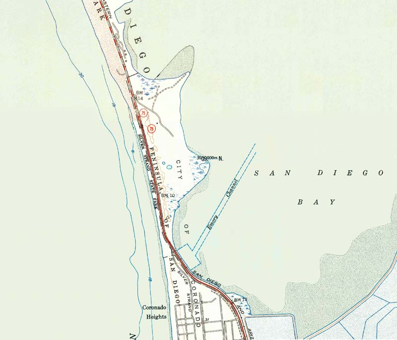
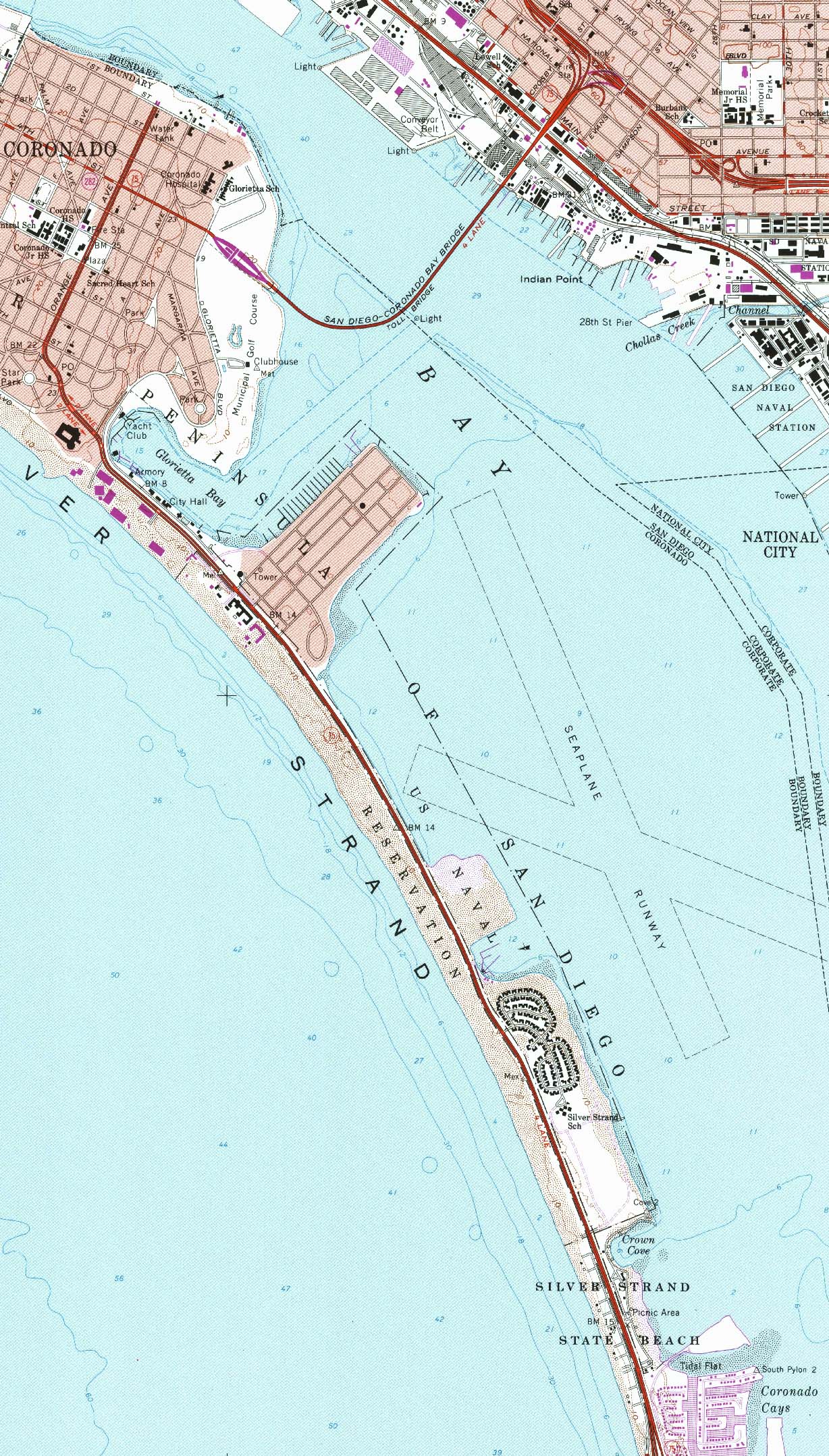
This USGS map of the Coronado Cays in 1953 shows two small ponds in the center of the area where Trinidad Village will be developed in the 1970s. These may have been the location of the Russian spring. A small black square along the old road into the Cays may have been the old Carillo ranch home and the hog ranch of the Riis family.
1888 - "Coronado Cays. This stretch of land, 4-miles south of Coronado, along the Silver Strand, has an interesting past. The Hotel Del Coronado Hotel Del Coronado fell on rough financial times before it even opened in 1888. Mr. John D. Spreckels rode in on his wealthy white horse and took over the hotel and other businesses owned by the Coronado Beach Company. The Beach Company owned the land, Rancho Carillo or "Hog Ranch," which was leased by the Riis family. Spreckels had the grand idea to let the hogs pig out on the waste disposal from the Hotel Del, Coronado's grand dame. Hogs are such pigs. They'll eat anything. After a few short years, the Riis family lost the farm in 1916 after a devastating flood from the Otay water disaster. Their livelihood was left, literally, in the dumps. They had no choice, but to leave. At that time, Coronado had a dirty little secret. The residents and businesses turned a blind eye and took to using the island's nooks, crannies and outlying areas for their own disposal sites. Spreckels who had more money than God, decided to build an incinerator on the Carillo Ranch property to handle the island's trash. It became the official city dump. Everything went to this 236 acre site for disposal. In 1948, the City of Coronado took over the site. In 1955, the dump was finally dumped. The property, even with the dump, languished for 20 years before promise rose from the ashes. In 1967, speculating that green would come to Coronado from the construction of the blue Coronado Bay Bridge, Atlantic Richfield bought the Carillo Ranch property and went into partnership with Cedric Sanders to build the Coronado Cays. In 1969, development started on the Cays with full build out completed in 1995. Land-fill, dredged from the bottom of the San Diego Bay to create the Cays, was later used to build the property that eventually became Lowe's Coronado Bay Resort. To this day, the Coronado Cays is the only marina residential development with personal boat slips in all of San Diego and north to Newport Beach, California." ( The Secret Story of the Coronado Cays, 2008 ) 1900 - Tent City expanded south of the hotel 1900-1910. About half way down the Strand from Tent City were several coves where small palm shacks were built for overnight camping or day picnics. ( Carlin, Coronado: the Enchanted Island, 1998, p. 112. ) 1903 - George Neale bought the Coronado Dairy Farm and moved the stock from the Silver Strand to Sixth Street in Coronado. ( Carlin, Coronado: the Enchanted Island, 1998, p. 62. ) 1911 - Henry and Rudolph Riis in 1911 leased the spit of land four miles south of the Tent City for the purpose of raising hogs. Their 200-acre ranch known as "Hog Ranch" started south of Brickyard Cove (later known as Crown Cove). The hogs ate garbage from the Hotel del Coronado and the city of Coronado. The brothers also raised chickens and cows and horses. The ranch was closed when it was damaged by the rising bay waters following the 1916 flood. The topsoil was cleared off and taken for use at the Coronado Country Club golf course. The people of Coronado began dumping trash in the vacant land and it became an unofficial city dump. ( Carlin, Coronado: the Enchanted Island, 1998, p. 15. ) 1913 - Howard Welty reported in 1913 that he found arrowheads and shellmounds and a number of Indian campsites on Coronado's North and South Island. In the early 1930s, archaeologist Arthur Woodhead reported finding artifacts on the Silver Strand. ( Carlin, Coronado: the Enchanted Island, 1998, p. 16-17. ) 1916 - Coronado Heights had several hog and chicken ranches, Allen's Sand Pit, and several companies gathering kelp. ( Carlin, Coronado: the Enchanted Island, 1998, p. 144. )
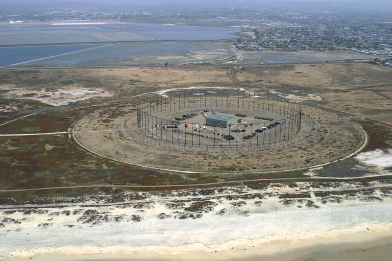
The Elephant Cage
1920 - The Navy Radio Compass Station was established on the Coronado Military Reservation on the Silver Strand; in 1932 it became a Navy Direction Finder Station; in 1940 it became a Direction Finder Station with a unit of 112 WAVES assigned to SIGINT operations. In 1947, it became Naval Radio Receiving Station Imperial Beach, and in 1965 it received a Wullenweber Circular Antenna Array, nicknamed the "elephant cage." The circular antenna was the last of the 16 high-frequency direction-finding arrays built to detect Soviet submarines and other radio emissions in the range of 2 to 32 MHz in the Pacific Ocean. "Surrounding the two-story operations building were two concentric rings of HF antennas, one for shorter HF wavelengths, containing 120 sleeve monopoles, and one for longer HF wavelengths, containing 40 folded dipoles. The shorter wavelength ring was about 260 metres in diameter and the longer wavelength ring was about 230 metres in diameter. Inside each ring there was also a large wire screen, supported by 80 towers, which was designed to prevent HF signals from crossing the array and interfering with its operations." (quote from Lux Ex Umbra). The array was closed Sept. 30, 1999. 1924 - The new concrete Strand road opened June 29, 1924. ( Carlin, Coronado: the Enchanted Island, 1998, p. 166. ) 1928 - John E. Blackman of Coronado bought the San Diego Chamber of Commerce industrial building tidelands of 600 yards at the southern end of the bay near Chula Vista. He wanted to develop these lands by cutting a second channel through the Strand for ocean-going vessels to enter the southern bay. Some people opposed the plan and sought to save the Strand as a state park, but the channel idea failed to get funding. ( Carlin, Coronado: the Enchanted Island, 1998, p. 173. )
1936 - The CCC finished construction of the first 8 acres of the park on the bay side. ( Carlin, Coronado: the Enchanted Island, 1998, p. 191. ) 1936 - Dredging of the bay deposited sand on the ocean side of the Strand. Ocean currents carried this sand north to form the wide beach on Coronado. ( Carlin, Coronado: the Enchanted Island, 1998, p. 193. ) 1940 - The bay was dredged to create a Navy Seaplane Basin on the bay side of the Strand, two miles south of Coronado. Dredging also began in 1940 to fill the Spanish Bight between North and South Island, a big project that was not finished until 1944. ( Carlin, Coronado: the Enchanted Island,, 1998, p. 202. ) 1940 - The Army leased Coronado Heights to construct Fort Emory and fortifications for large coastal guns. In 1942 Fort Emory was transferred to the Navy for an Amphibious Training Base. ( Carlin, Coronado: the Enchanted Island, 1998, p. 214. ) 1941 - Navy dredging allowed 185 acres of tidelands on the bay side of the Silver Strand, south of Coronado, to be reclaimed for the Amphibious Base Headquarters. And in 1945 over 200 acres were added to the beach on the ocean side of the Silver Strand for amphibious landing operations. Today the Naval Amphibious Base extends along approximately 4 miles of the Silver Strand and is the only naval amphibious base on the West Coast. (Hinds, "San Diego's Military Sites," mss, 1986.) 1941 - When the state widened highway 75 in 1941, the new road took up much of Tent City and the old resort disappeared. ( The San Diego Union, June 12, 1983) 1943 - Navy Frogmen, now known as SEALS, began training at the Amphibious Base in Coronado. ( Carlin, Coronado: the Enchanted Island, 1998, p. 221. ) 1948 - Voters approved the purchase of Brickyard Cove for $175,000 to develop a recreational site. Hog Ranch was named Rancho Carillo, but the area remained a trash dump for 20 years. ( Carlin, Coronado: the Enchanted Island, 1998, p. 230. ) 1949 - At a council meeting on April 5, the Silver Strand area was formally annexed by ordinance. Now the city limits legally extended all the way down the Strand to the Fort Emory area, adjacent to the recently purchased Rancho Carrillo property, although the majority of the sand constituted a state park. ( Carlin, Coronado: the Enchanted Island, 1998, p. 233. ) 1955 - the State Division of Highways announced that in mid-January, the four-lane divided highway construction would begin on the Silver Strand. ( Carlin, Coronado: the Enchanted Island, 1998, p. 248. ) 1963 - The Navy broke ground for a 250 house project of ranch-type 3-4 bedroom housing on the Strand at the Naval Amphibious Base at a cost of $4.75 million. ( Carlin, Coronado: the Enchanted Island, 1998, p. 264. ) 1965 - The government built the new Silver Strand Elementary School at Silverado Park in January. The buildings, designed by Paderewski, Dean and Associates, were made to resemble South Sea Island huts, but of more rugged construction. ( Carlin, Coronado: the Enchanted Island, 1998, p. 267. ) 1968 - "Ground-breaking ceremonies today will mark the beginning of San Diego Bay's first marina-residential community, a $75 million Silver Strand development to be called Coronado Cay. Cedric Sanders, a Santa Ana land developer, said plans call for the first of 1,509 building sites to be ready by next summer. 'Dredging probably will begin within two weeks,' said Sanders, president of Coronado Cays Corp. The development is being undertaken by Coronado Cays and Signal Properties, Inc., a subsidiary of Signal Oil. Civic leaders from Coronado and the Unified Port District will attend the ceremonies this afternoon. California Senators George Murphy and Thomas Kuchel and Rep. Bob Wilson R-San Diego have accepted invitations to attend. The development will be on 228 acres purchased a year ago from the city of Coronado and on 140 acres of tidelands which surround Coronado on the bay side. In exchange for use of the 140 acres of tidelands. the San Diego Unified Port District will receive one new bayside island and perhaps part of another, to be connected to Coronado by causeways. "This is going to be a complete community," said Sanders. 'There will be homes, apartments, stores and shops.' Phase One will include development of 181 waterfront lots at Turtle Cay and 99 other sites in Jamaica Village. 'A park and a school site will be included in Phase One,' said Sanders. 'Also, the dredging will create the northern island, which will be about 15 acres.' The Guy F. Atkinson Co. has been awarded the dredging contract, which will consist of creation of a channel into the property, and the bulkhead work around the island and the lot sites. Phase One will cost about S4.5 million. One of the major costs will be a 4.5-mile sewer and utility line from the city of Coronado. Waterfront lots will range from $32,000 to $100,000. Jamaica Village homes will range from $32,000 to $45,000, according to Sanders. 'Jamaica Village will have its own beach club," he said. "Ultimately, there will be a yacht club complex.' Coronado Cay is unique in San Diego Bay because of the tideland trust which prohibits development of private dwellings on port tidelands. The dwelling sites will be on uplands, connected to the bay by channels, so Coronado Cay will not violate the trust. ("Residential Marina Project To Begin On Silver Strand," by Tim Shepard, The San Diego Union, Sept. 6, 1968 ) 1968 - On Sept. 12, 1968, the Atlantic-Richfield Company signed a 66-year lease with the Port District to begin construction of the Coronado Cays. The first phase was completed Sept. 4, 1969. ( Carlin, Coronado: the Enchanted Island, 1998, p. 275. ) 1968 - Mayor Curran said that more than a year ago he proposed a study of an airport on the seaward side of the Strand in the South Bay area, pointing out that the shallow waters there are favorable to a landfill. A second entrance to the bay and dredging operations involved would produce enormous quantities of soil to create a man-made peninsula to accommodate an international airport with the unobstructed Pacific for approach and takeoff. (The San Diego Union, Jan 15, 1968) 1969 - Three Marinas Expected To Spark New Boating Boom. A South Bay boating boom is assured by plans for marinas at Chula Vista, Imperial Beach and Coronado's Silver Strand. Land for the three marinas, all of which will have public facilities, already has been set aside. At National City, the San Diego Unified Port District recently opened the county's largest small-boat launching ramp. The new ramp, dedicated April 20, is at the 24th Street Marine Terminal and fronts on the mouth of the Sweetwater Flood Control Channel. The 10-lane concrete ramp is 150 feet wide and is complemented by a paved and lighted parking lot, landscaping and rest rooms. Port commissioners are considering a proposal for a maritime park adjacent to the launching ramp for fishing, picnicking and other activities. "I have an idea that this little area is going to turn into about the hottest small-boat facility in the county," a port official said. Previously, the only smallboat launching ramp in the South Bay area was the three-lane facility north of the Rohr Corp. plant in Chula Vista. That ramp, said the port official, will be supplanted by a marina planned at the foot of J Street in Chula Vista. When the marina is finished, he said, it will have restaurants, hotels, a small-boat launching ramp and slips for more than 1,000 yachts. "It will have a land area about the same size as Shelter Island," the official said. Already, 31 acres for the marina have been created with fill from dredging of the bay channel. As soon as federal funds are available to help finance further dredging, three additional land projections will be formed at the marina site, the official said. ( The San Diego Union, Apr. 30, 1969 ) 1972 - John R. Mock of Hendrick and Mock won an Architects' Award by the Unit Masonry Association for the design of a barracks complex consisting of four L-shaped four-story towers at the Naval Amphibious Base in Coronado. (The San Diego Union, Mar. 5, 1972) 1975 - During October, the biggest dredging project in the history of the region deepened San Diego Bay. Coronado, the Silver Strand, and Imperial Beach areas received bay bottom to replace the beach land lost by erosion. Thirty million cubic yards of sand were dredged from San Diego Harbor. One million cubic yards of that deposit was made north of the Hotel and sixteen million deposited southward, gready widening the beach. ( Carlin, Coronado: the Enchanted Island, 1998, p. 285. ) 1976 - The Army Corps of Engineers received a mandate from the South Bay this week: a second entrance to San Diego Bay is most welcome, but only with a bridge to link the Silver Strand. The most notable opposition came from Coronado Mayor Virginia Bridge, who indicated her city council was opposed to the entire project, most especially if a bridge were not built. Many South Bay residents, particularly in Imperial Beach, work at the North Island Naval Air Station at the north end of Coronado and use the Silver Strand to commute. "I realize it will be the South Bay that will benefit from the cut through the Silver Strand," said Coronado Mayor Bridge. "but it will be our community that will be cut. We are still suffering from the separation of our community from the Coronado Bridge." The Coronado Cays is south of the proposed second entrance and within Coronado city limits. The Navy favors a second entrance to prevent blockage of ships in the event of a harbor disaster. Should the Coronado Bridge and a new bridge both collapse, Navy vessels couId be bottlenecked in the South Bay, the Navy has warned. But the Navy has yet to officially endorse the second entrance project, fearing the monetary obligation that would go along with such a commitment. The Army Corps of Engineers considers the Navy's endorsement essential to beginning the project in the near future. (Chula Vista Star-News, June 27, 1976 ) 1988 - High tides and winds gusting to 65 miles per hour combined in January 1988 to blast Coronado with one of the worst storms in years, causing $1.5 million dollars in public and private damage. The beaches were hit hard and the Silver Strand Highway was closed. ( Carlin, Coronado: the Enchanted Island, 1998, p. 290. ) 1989 - The tract of Navy housing with Spanish style buildings off State Route 75 near Silver Strand Elementary School opened on September 5th, . The housing provided much needed quarters for military families. ( Carlin, Coronado: the Enchanted Island, 1998, p. 293. ) 1991 - Loews Coronado Bay Resort opened Oct. 1, 1991, with 440 rooms on a 14-acre peninsula called Crown Isle. This put an end to the earlier efforts of a group of Cays owners who formed the Crown Isle Defense Fund in support of a second harbor entrance in the bay north of the Cays. ( Carlin, Coronado: the Enchanted Island, 1998, p. 296. )
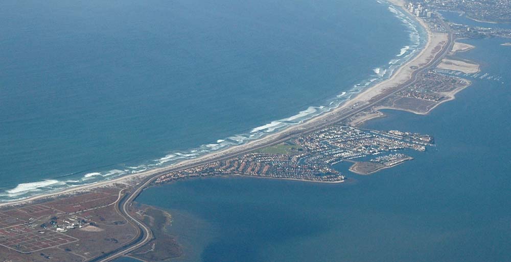
The Silver Strand and the Coronado Cays in 2006
SOURCES:
|
||||||
|
Home •
About Us •
Next Meeting •
Latest News •
Resources •
Organizations •
Exhibits •
Bulletins
Contact
|
||||||
|
This web page was created Feb. 1, 2015 by Steve Schoenherr for the South Bay Historical Society | Copyright © 2015
|