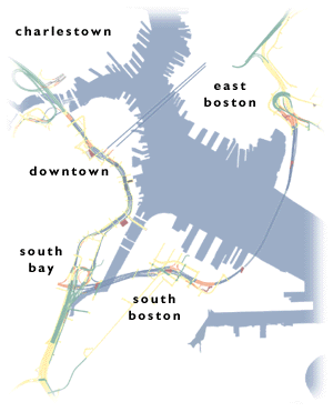
 "Boston, Massachusetts has a world-class traffic problem, an elevated six-lane highway called the Central Artery that runs through the center of downtown. When it opened in 1959, the Central Artery comfortably carried about 75,000 vehicles a day. Today it carries upwards of 200,000, quite uncomfortably, making it one of the most congested highways in the United States. Traffic crawls for more than 10 hours each day. The accident rate on the deteriorating elevated highway is four times the national average for urban Interstates. The same problem has plagued the two tunnels under Boston Harbor between downtown Boston and East Boston/Logan Airport. Without major improvements to the Central Artery and the harbor crossings, Boston can expect a stop-and-go traffic jam for up to 16 hours a day - every waking hour - by 2010. The annual cost to motorists from this congestion - in terms of an elevated accident rate, wasted fuel from idling in stalled traffic, and late delivery charges - is estimated to be $500 million. And traffic isn't the only problem the Central Artery causes in Boston. The elevated highway (which displaced 20,000 residents when it was built) also cuts off Boston's North End and Waterfront neighborhoods from the downtown, limiting these areas' ability to participate in the city's economic life. This extraordinary traffic mess represents a continuous economic and quality-of-life drain on Boston and New England. The solution is called the Central Artery/Tunnel Project (CA/T), now under construction by the Massachusetts Turnpike Authority.
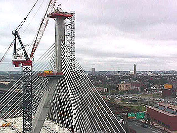
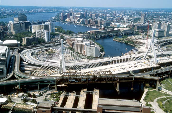
The project has two major components: The six-lane elevated highway will be replaced with an eight-to-ten-lane underground expressway directly beneath the existing road, culminating at its northern limit in a 14-lane, two-bridge crossing of the Charles River. When the underground highway is finished, the crumbling elevated road will be demolished and replaced by open space and modest development. I-90 (the Massachusetts Turnpike) will be extended from its current terminus south of downtown Boston through a tunnel beneath South Boston and Boston Harbor to Logan Airport. The first link in this new connection - the four-lane Ted Williams Tunnel under the harbor - was finished in December 1995.
 |
 |
The project also includes four major highway interchanges to connect the new roadways with the existing regional highway system. At Logan Airport, a new interchange will carry traffic between I-90 and Route 1A as well as onto the airport road system. In South Boston, a mostly underground interchange will carry traffic between I-90 and the fast-developing waterfront and convention center area. At the northern limit of the project, a new interchange will connect I-93 north of the Charles River to the Tobin Bridge, Storrow Drive, and the new underground highway.
At the southern end of the underground highway, the interchange between I-90 and I-93 will be completely rebuilt on six levels, two subterranean to connect with the underground Central Artery and the Turnpike extension through South Boston. The interchange will carry a total of 28 routes, including High Occupancy Vehicle lanes, and channel traffic to and from Logan Airport to the east. A fifth interchange, at Massachusetts Avenue on I-93, has already been substantially rebuilt by the project. It will function as a part of the larger I-90/I-93 Interchange when the project is finished but today is already helping improve Southeast Expressway traffic flow following early phases of reconstruction.
The Central Artery project is public works on a scale comparable to some of the great projects of the last century -- the Panama Canal, the English Channel Tunnel (the "Chunnel"), the Trans-Alaska Pipeline. Each of these projects presented unique challenges: The Panama Canal confronted earthslides, malaria, yellow fever, and Central American jungles. The Chunnel was dug from either end, 31 miles apart, meeting at a precise point under the channel floor. The Alaska Pipeline contended with vast distances, freezing temperatures, and major environmental concerns. The Central Artery project's unique challenge is the fact that it is being built in the middle of a city. Work of the CA/T project's magnitude and duration has never been attempted in the heart of an urban area, but unlike any other major highway project, the CA/T is designed to maintain traffic capacity and access to residents and businesses - to keep the city open for business - throughout construction. Highway projects of the 1950s and 1960s, when the interstates were first built, gave very little consideration to the communities in the path of the new roads, with disruption and dislocation the rule of the day. Recognizing that failing to maintain Boston's economic viability during construction would damage the city's competitive position for years to come, project planners worked with environmental and other oversight and permitting agencies, community groups, businesses, and political leaders to create consensus on how the project would be built. The process of keeping the city open and making certain that all affected groups are treated fairly is called mitigation, and it takes up a fourth of the project's budget.
Along with improving mobility in notoriously congested downtown Boston, the Central Artery project was conceived to reconnect neighborhoods severed by the old elevated highway, and improve the quality of life in the city beyond the limited confines of the new expressway. Apart from a 12 percent reduction in citywide carbon monoxide levels, major project benefits include creation of more than 260 acres of open land, including 30 acres where the existing Central Artery now stands, more than 100 acres at Spectacle Island in Boston Harbor (where project dirt is capping an abandoned dump), and 40 more acres of new parks in and around downtown Boston. Clay and dirt from the project are being used to fill and cap landfills throughout the Boston area.
The project has been under construction since late 1991. As of April 1, 2001, final design is about 99 percent complete, construction about 70.7 percent complete. A bridge across the Charles River connecting I-93 in Charlestown with Leverett Circle and Storrow Drive was opened in the Fall of 1999. The I-90 extension through South Boston to the Ted Williams Tunnel and Logan Airport will open in September 2002. The northbound lanes of the underground highway replacing the elevated Central Artery open in November 2002, the southbound lanes in November 2003. The entire project will be finished in 2004, including demolition of the elevated highway and restoration of the surface. For more information click to see our project schedule section.
The Central Artery/Tunnel Project is owned and managed by the Massachusetts Turnpike Authority (MTA), and is part of the Metropolitan Highway System (MHS). Design and construction management consulting is provided by Bechtel/Parsons Brinckerhoff, a joint venture of Bechtel Corporation of San Francisco and Parsons Brinckerhoff Quade & Douglas, Inc., of New York." (summary quoted from http://www.bigdig.com/thtml/summary.htm)